|
Multnomah Falls is the most visited natural recreation area in the Pacific Northwest, with over two million visitors annually. They provide a year round attraction for tourists, that is absolutely stunning in natural beauty. According to the legend from the native Multnomah tribe, the waterfall was formed after a young woman sacrificed herself to the Great Spirit, by jumping over the cliff. She did this to save the Multnomah village from a plague. After her death, water began to flow from above the cliff, thus creating the waterfalls. 
Multnomah Falls in the early years of tourism circa 1915. Another Native American story tells that the Falls were created, to win the heart of a young princess who wanted a hidden place to bathe. The Falls are credited by the United States Forest Service, as being the second tallest year-round waterfall in the United States. This distinction is in dispute, as the World Waterfall Database does not differentiate between seasonal and year round waterfalls. It lists Multnomah as the 156th tallest waterfall in the country. The Multnomah Falls are ranked 434 in height, globally. The Falls encompass a 10 foot (3M), average width. Multnomah Falls consist of cascades of water that drop in two major steps. There is the Upper Falls of 542 feet or 165 meters and Lower Falls of 69 feet or 21 meters. In between there is a 9 foot drop in elevation between the two. These two separate drops are the result of more easily eroded basalt, at the base of the Upper Falls. 
The falls while frozen in December 2013. Larch Mountain provides underground springs, which are the year-round source of water for Multnomah Creek. Runoff from snow in the spring and rainwater throughout the year, supplement this supply, which maintain the falls constant flow. However, late winter and early spring is when the water is most abundant and therefore making the falls most spectacular. The land surrounding the falls, was developed by Simon Benson in the early 20th century. Over time, he constructed an easily traversed pathway, and a viewing bridge. In early 1915, the Portland Progressive Business Men’s Club organized an effort to build a trail from the base of Multnomah Falls, extending to the top of Larch Mountain. The Club along with Portland financier Simon Benson,who pledged an additional $3,000 USD (United States Dollar), worked to fund the project. The United Forest Service agreed to add $1,500 USD to the undertaking. The government agency agreed to survey and engineer the trail to a lookout, on top of the mountain. 
Benson Bridge Benson for his part, financed Italian stonemasons to design and construct a bridge at the Falls, which would permit future visitor access. Named Benson Footbridge, it spans the Lower Falls at the height of 105 feet. It also provides an expansive view of the Upper Falls. A paved foot trail leads to the 45 foot Benson Footbridge. It allows travelers to cross 105 feet above the lower cascade. After providing a viewpoint of the Upper Falls, the trail continues to ascend to an elevation of 785 feet. The pathway then later descends to an observation deck, 660 feet overlooking the edge of the Falls. From there one can view the Colombia Gorge and the Little Multnomah Falls,located further up the stream. 
Wahkeena Falls The same year, Benson donated over 1,400 acres or 570 hectares of land, which included most of the Multnomah Falls, as well as nearby Wahkeena (most beautiful in the Yakima language)) Falls to the city of Portland. The 240 feet high Wahkeena Falls, are accessible by a 0.6 mile trail. A mile high trail from the base of Wahkeena Falls to the top, is quite popular among locals for its spellbinding views, wildflowers and lack of larger crowds of tourists. These falls are presently closed due to the 2017 Eagle Creek Fire The Oregon and Navigation Company, would donate the land at the base of the Falls. This was done by agreement, that a lodge would soon be built at the site. Architect A. E. Doyle was commissioned by the city of Portland, to build Multnomah Falls Lodge in 1915. It was constructed in the Cascadian architectural style, using native split field stones laid irregularly. 
Multnomah Falls Lodge and Footpath The lodge features, a steep pitched cedar shingled gable roof. Included in the design are a number of large chimneys for heating and dormers for the windows. Through the mid part of the 20th century, travelers could obtain both accommodation and meals at the Multnomah Falls Lodge. Today there is still a restaurant on the second floor, that serves breakfast,lunch and dinner. There is also a visitor and interpretive center, snack bar, and a gift shop. The Lodge completed in 1925 and the surrounding footpaths, were added to the National Register of Historical Places in 1981. 
Colombian River Gorge Today, the state of Oregon maintains a switchback trail that ascends to a rock formation, that is 100 feet above the Falls. This pathway descends to an observation deck that overlooks the edge of the Falls. There are a number of trails that lead out from the main pathway. These allow access to nearby waterfalls. The Falls themselves, would be later donated from the city of Portland to the National Forest Service. Multnomah Falls were formed about 15,000 year ago,likely the creation of the Missoula Floods, at the end of the last ice age. 
Missoula Floods The now famous Falls were identified by the famous early American explorers William Clark and Meriwether Lewis, during the 1805 expedition through the Columbia River Gorge. The actual naming of the Multnomah Falls remains a mystery. It has been suggested that a prominent mercantile clerk in Portland by the name of S.G. Reed, may have been the first to use the moniker. His objective would have been to popularize sites along the Colombia River, for the new steamboat excursions, that were taking place in the 19th century. How To Get There There are 3 different routes that one can take to arrive at the Multnomah Falls.
Arranging Transportation If one does not have a car, or chooses not to deal with parking, one can take the Colombia Gorge Express Shuttle from Portland. Mailing Address Columbia River Gorge National Scenic Area Office 
Simon Benson 1851- 1942 902 Wasco Avenue, Suite 200 Hood River, Oregon 97031 Phone Number (541) 308-1700 Website: https://www.fs.usda.gov/recarea/crgnsa/recarea/?recid=30026 Entrance Fee There are no fees, to visit either Multnomah Falls or Wahkeena Falls. Days and Hours of Park Operations The Visitor Center and the site in general, is open from 9:00 am to 5:00 pm. Facilitates are open and available year round,7 days a week. The Multnomah Falls Lodge Visitor Center phone number is (503) 695-2372. Lodging Is available in the city of Portland. Helpful Hints
The post Multnomah Falls, Oregon: America’s Most Beautiful Waterfall appeared first on WanderingTrader. from http://wanderingtrader.com/travel-blog/united-states/multnomah-falls-oregon-americas-beautiful-waterfall/
0 Comments
Who wouldn’t like to drop everything and tour the world? The trouble is – and that’s the trouble, those three words. It will cost lots of money, you need to focus on work, visas will be a pain, you might not like the food, you don’t know the language. All of those are probably spot-on correct, but the point is, it’s so easy to find reasons not to do something. Turn the question around and look at the reasons why you should, and suddenly those “the trouble is…..” factors become mere obstacles to be negotiated or challenges to be faced. There’s a whole world out there with experiences beyond your imagination just waiting for you. When you get back, the world you left behind will still be here, but as friends and family stop by, it won’t just be the stunning new artwork you’ve commissioned a canvas print company to create from your travel photos that will have changed. You’ll be a different, more fulfilled person too. Travel does that to us, so stop thinking troubles and get started with the plan. What’s your budget?Let’s look at each of those trouble factors and hit them head on. The first is money. Now, by far the most expensive part of a round the world trip is the flights, so this is where you have to think smart. Sure, there are those who relish the challenge of travelling by land and sea only, but that is a whole topic in itself, so we’ll assume you are going by air. There are round the world tickets you can buy for as little as £1,000. Of course, with these, there is no backtracking, and you’ll be on a set schedule. But hey, some people pay that for a return flight to Asia, so it is well worth a thought. How much time?Got work constraints? Well, you can still travel the world in 10 days and enjoy the experience of a lifetime. Of course, the more time you can devote to your trip, the more you can experience at each stop, so have a chat with your boss about taking some extended leave or a sabbatical. In this age of remote working, you might still be able to “clock in” every few days while you are away – offer that as a suggestion, and you never know what might be possible. Where are you going?You might think this is the first question to answer, but you really need to get the above points clear first, as the countries you will visit will depend on the time you have, your budget and your travel flexibility. For example, the most cost-effective round the world tickets usually start in Europe and involve stops in North America, Australia and Asia. If you have your heart set on including Africa and South America in the agenda, it will probably work out a little more costly. These days, the world is a smaller place. Get out there and explore it, there are far more reasons to do so than not! The post Planning your own world tour appeared first on WanderingTrader. from http://wanderingtrader.com/travel-advice/planning-your-own-world-tour/
In 2018, the historic line would be bought by Carnival Cruise Lines. This scenic mountain trip, a wonder of steel and timber, is the 26th stop in the travel series Off The Beaten Path. The now purely tourist line, still uses vintage parlor cars. The oldest four of them were built in 1881, with four new ones created in 2007. The recent additions have followed the same 19th century design. Three of the cars, have been equipped with wheel chair lifts. In 1896, gold was discovered by George Carmack and two native American companions, Skookum Jim and Dawson Charlie. As a result, the idea of a rail-line, quickly became seen as a viable business operation. Men and women were arriving in ever greater numbers, to mine gold, during the last years of the 19th century. 
First train headed to White Pass, 1899. At the time, the United States was in the midst of a depression. Tens of thousands of prospectors would come and make the arduous and dangerous 600 mile overland trek, to the supposed gold fields. The original construction of the White Pass & Yukon Route began in 1898, during a period of time that has become known as, the Klondike Gold Rush. The new rail-line, was used as a means to reach the gold fields. Upon completion in 1900, it soon became the main route to the interior of the Yukon territory. Three separate companies had been organized to build the rail link from Skagway, Alaska to Fort Selkirk, Yukon. Mostly financed by British investors, the 325 mile (523 kilometers) rail-line attempted to follow the difficult landscape, as much as possible. 
Skagway, Alaska There were a number of human obstacles, during the building of the railway. The local city government of Skagway and the town’s crime boss Soapy Smith, were among them. Events would take a turn, when Samuel H. Graves the company president, was elected as head of the vigilante organization. The objective was to root out Soapy and his gang. In July of 1898, Soapy Smith would be killed in the infamous Shootout on Juneau Wharf, by guards at one of the vigilante meetings. Graves would actually witness the killing. He helped manage railroad resources, in blocking off the escape routes of the Smith gang. This aided in their capture, which soon lead to a dramatic reduction in resistance, for general railway operations. 
Train entering the main tunnel. The same month, the line would now become the first train in Alaska, to go into regular service. The charter rights and concessions of the three companies, would soon be acquired by the White Pass & Yukon Railway Company Limited, a new company organized in London. The following year, building on the rail-line reached the White Pass Summit, a full 22 miles (32 kilometers) from Skagway. At 2,885 feet or 879 meters, it was one of the most challenging points in the construction process. The obstacles facing the builders of this rail-line were almost unprecedented. Sheer cliffs rising for hundreds of feet, with no real surveys. 
Looking south from the tunnel in winter. Snowdrifts in the winter time, could reach up to 30 feet and temperatures would sometimes dip to 60 degrees below zero. While snow drifts remained an ongoing issue, the use of a rotary snow plow, made it possible to continue work and service on the line, except during times of blizzards. However, the fact that the railroad was largely built in the rocks, this made it nearly immune from spring washouts, during the rapid spring snow melts. A further complication was the reality that the local wood could not be used ,since it splintered too easily. Every bridge timber had to be imported, as were most of the other construction supplies. More than 450 tons of explosives, would be required in the building of the railroad. 
One of the present-day White Pass diesel locomotives. For the first 20 miles coming out of Skagway, the construction costs averaged $100,000 USD (United States Dollar) per mile. This was a staggering amount for the time. It is equal to around $3 million USD, in today’s valuation. In addition, a 250 foot (76.2 meters) tunnel, had to be blasted out of the rock. There is another tunnel and numerous bridges and trestles, throughout the rail-line, that were quite difficult and expensive to build. The railroad features steep grades of almost 3.9%. The tight curves of the White Pass, called for a narrow gauge railroad. This meant that the rails would be only three feet apart on a ten foot wide road bed. At least 35 workers would lose their lives, in the building of the rail-line. A total of 35,000 individuals would work on the railroad, during its construction. 
White Pass and Yukon Route No 93 The railway was completed in July 1900, with service starting the following month. The entire project cost $10 million USD. It was the product of British financing, Canadian contracting and American engineering. However by then, the Gold Rush was pretty much over and professional mining for copper, lead, silver had already begun. The White Pass & Yukon Railway Company would survive the Great Depression of the 1930’s and would later be leased by the United States Army, during World War II. 
White Pass & Yukon Route. In the post war era, passenger traffic on the White Pass & Yukon Railway Company (WP&YR) was increasing, as cruise ships started to visit Alaska’s Inside Passage. Until 1978, there was not even a road from Skagway to Whitehorse. However, WP & YR would still rely on the movement of ores, from the mines to the coast, in order to stay in business. In 1982, as metal prices plunged, the mines starting closing, soon dooming the railroad as a commercial enterprise. The railway although closed, was the focus of the first episode of the BBC television series Great Little Railways in 1983. 
White Pass and Yukon Route Railroad Building is now a museum and home of the Klondike Gold Rush National Historical Park. The 2018 purchase of the WP & YR by Carnival Cruise Lines for $290 million USD, will ensure the survivability of the line, and possibly even pay for further extensions, if there is enough tourist interest in new projects. Visitors from the train can now view a breathtaking panorama of mountains, with glaciers, gorges, waterfalls, and historic sites, as well as the trek of the railway itself. The present length of the line is 107 miles (172 kilometers) from Skagway to Whitehorse. Another line runs for 67.5 miles or 108.6 kilometers from Skagway to Carcross (originally known as Caribou Crossing), in the Yukon Territory of Canada. The small city of Skagway is now a tourist spot, home to Gold Rush era buildings, now part of the Klondike Gold Rush National Historic Park. Location The White Pass and Yukon Railway can be accessed from Skagway, Alaska a compact city in a southeast portion of the state, along the popular Inside Passage. Arranging A Tour Phone Number for reservations on the White Pass and Yukon Route 1-(800-343-7373) or by e-mail: [email protected] Fax number: (907) 383 – 2734 Mailing Address 231 Second Avenue PO Box 435 Skagway, Alaska 99840-0435 Website: https://wpyr.com/ One way trips and overnight camping, are also available for tourists, outside the main rail excursions. Entrance Fee Reservations are required, on all of the train excursions. There are a number of different reservations that can be made, depending on your interest and time available. The White Pass Summit Excursion, the most popular, allows a visitor the opportunity to retrace the original route to the White Pass Summit, passing Bridal Veil Falls, Inspiration Point and Dead Horse Gulch. The cost of an adult fare is $125.00 USD. For a child (ages 3-12 )the cost is $62.50 USD. Infants under 3 are admitted at no cost. If you are arriving by cruise ship, the tour is available through the Shore Excursion Department of your cruise line. This will provide you dockside service, so you can board the train on the pier. The Bennett Scenic Journey cost for an adult fare is $234.00 USD. For a child (ages 3-12 )the cost is $117.00 USD. Infants under 3, are admitted at no cost. Days and Hours of Park Operations The White Pass Summit Excursion is 40 miles round trip and will take a total of 3 to 3.5 hours, to complete. Complimentary bottled water is provided and each rail car is equipped with a restroom. No passport is needed, for this particular excursion. Skagway to White Pass is at 8:15 AM to 12:45 PM daily local time – 4:30 PM on Tuesday and Wednesday only, from the end of May to the end of August. The Bennett Scenic Journey allows a traveler to go the 67.5 miles by train (120 miles round trip) between Skagway and Carcross, in the Yukon Territory. It is along the same route that the Klondike adventurers traveled in 1898. The trip will take about 8 hours. Lunch will be provided and will be served on board. Dietary options provided, if requested in advance. Bottled water is included. Each rail-car is equipped, with a restroom. This train is not outfitted, with a wheel chair lift. The excursion features a 45 minute layover in Bennett Station. One can visit the White Pass Museum and a self guided walking tour, of the historic gold rush town. A passport is required, since you will be entering Canada. The train to Carcross leaves at 7:45 AM on Tuesday,Wednesday, Thursday, Friday and Sunday from the end of May, to the beginning of September. A bus will return you to Skagway. The Bus to Carcross, with a train ride to Skagway leaves at 9:30 AM. on Tuesday, Wednesday, Thursday, Saturday and Sunday. The Fraser Meadows Steam Excursion was not running, throughout all of 2018. Normal operations to resume in the near future. The 54 mile round trip, takes the tourist from Skagway pass White Pass Summit, to Fraser Meadows. The duration of the trip is about 4 hours. The fully narrated tour, passes through two tunnels and by waterfalls, as one goes over sky high trestles. The train is not equipped with a wheel chair lift, but each car does have a restroom. Complimentary bottled water is provided. A passport is required since you will be leaving the United States and entering Canada. Lodging Is available in Skagway. Helpful Hints
The post White Pass And Yukon Route Railway In Alaska, A Most Scenic Mountain Trip appeared first on WanderingTrader. from http://wanderingtrader.com/travel-blog/united-states/white-pass-yukon-route-railway-in-alaska-most-scenic-mountain-trip/ 
Pure relaxation! Photo by Unknown / Public Domain For Americans and Europeans alike, the Caribbean is usually one of those destinations considered for special getaways, like honeymoons and milestone birthdays. And rightly so, since it is such an amazing region. With almost thirty countries being part of the Caribbean, there are a wide variety of islands to visit, all with their own characteristics. Some of the islands are easier to get to than others; in many cases with direct flights from major American airports but also from many other flight hubs around the world Hypnotic Music – Jamaica If you are looking for a typical Caribbean musical experience and vibe you should head to Jamaica. This is where what we today call reggae, an almost hypnotic music style driven by steady beats of drums or piano, was born in the 1960s. Bob Marley is probably the most well known contributor to this genre. Other types of music typical in the Caribbean include calypso, salsa, zouk, soca, ska and dancehall. Cosmopolitan buzz – Cayman Islands 
Residential area in the Cayman Islands Photo by Unknown / Public Domain If you are keen on experiencing a more cosmopolitan feel, then the Cayman Islands may be your preferred destination. George Town on Grand Cayman – the main island) offers plenty of typical tourist opportunities including museums, shopping and local eateries. Cruise ships frequently stop at the harbour, adding to the vibe of the capital. Grand Cayman is also home to the Seven Mile Beach, which is very popular with holiday makers and locals alike, ensuring this holiday destination offers culture as well as shopping and relaxation. Tropical hideaway – the Bahamas For those who fancy a quiet tropical hideaway (although technically not in the Caribbean Sea, but rather the Atlantic) the islands of the Bahamas may appeal. Located just 50 miles off the coast of Florida in the United States, the 700 islands making up the Bahamas really aren’t far away, and they offer plenty of opportunity for seclusion. Being a dream destination for many, there really is something for everyone, including white sandy beaches, a buzzing night life and amazing food. For those interested in golf, there are popular golf courses located at The Abacos, Freeport, The Exumas and Nassau & Paradise Island. For a slightly different experience, you can even swim with pigs off the Exuma island chain.
Photo by Unknown / Public Domain Swimming with pigs! For a truly amazing holiday, also consider making your way to some of these must see Caribbean landmarks including Paradise Island in the Bahamas, Dunn’s River Falls in Jamaica, Virgin Gorda in the British Virgin Islands, and El Yunque National Forrest and Old San Juan, both in Puerto Rico. Working in the Caribbean Essential to many travellers, including those adapting the wandering life style I have come to enjoy, is the availability and speed of internet connection. Looking at the latest yearly update by ICT Pulse, the connection speeds in the Caribbean are generally improving compared with previous years. Unfortunately, Barbados and Trinidad & Tobago are the only islands with stated download speeds of 1 Gbps. The Bahamas, Cayman Island and Jamaica also offer reasonable download speeds of 300 Mbps or 400 Mbps, with all other islands offering slower speeds. The cost of the different plans vary greatly, so it’ll be important to do proper research for anyone planning on a longer stay. The internet speeds for the Caribbean may sound slow, but for many they’ll still be sufficient. If not, perhaps ditch the work laptop, grab a traditional book and relax on one of the many beaches for a few days before returning to the connected world again. The post The Caribbean – Relaxation and Action All Combined appeared first on WanderingTrader. from http://wanderingtrader.com/travel-advice/caribbean-relaxation-action-combined/
Fly Geyser also known as Fly Ranch Geyser is located near the edge of Fly Reservoir in the Hualapai Geothermal Flats. It is near 5 feet or 1.5 meters high by 12 feet or 3.7 meters wide, if one counts the mound on which it sits. It is still growing, at a rate of several inches a year. The geyser itself has a constant flow of mineral water, throughout the year. The geyser is covered with thermophilic algae, which thrives in moist and hot environments. This simple plant life, is what gives the formation its vibrant shades of color. When the geothermal energy company hit water at the site in 1964, the water was 200 degrees, which although was hot, did not meet their specific needs. 
Fly Geyser and the surrounding pools The drilling activity did change things on the property. There was a second geyser, that was the result of a 1917 attempt, to find water for irrigation purposes. Being only a short distance from Fly Geyser, it was also at 200 degrees with minerals, not at all suitable for farming. It was then abandoned and over time, a 10 to 12 foot cone of calcium carbonate was formed. Once the pressure was released at Fly Geyser, the original geyser ceased hydraulic activity. It now lies dry, just a few hundred feet south, from the new geyser. Due to the multiple spouts that comprise Fly Geyser, it has not created one single cone, like the original geyser. The water comes out in a spray form, at the height of some five feet, building up the surrounding area. The geyser releases mineral enriched water into some 30 to 40 terraced pools that are situated across 74 acres. Some of them are hot and others consist of cold water. 
Black Rock Point in the Black Rock Desert There are two additional geysers in the general area, that were created in a similar way, which continue to grow. One geyser is about 3 feet (0.91 meters) and is shaped like a miniature volcano. The other one is cone shaped and has risen about 5 feet. The source of the heat for Fly Geyser, is attributed to a deep pool of molten rock, where rifting and tectonic faulting is an ongoing process. The 3,800 – acre property of Fly Ranch was purchased by the non-profit Burning Man Project, in June 2016. It was bought for $6.5 million USD (United States Dollar). The property has opened for guided tours this year. It is the first time, the Fly Geyser has been opened to the public, in decades. It provides controlled access to the geyser and the surrounding pools. It is easily visible from the road (only 1/3 a mile) and the plumes of water can be seen from miles away. Location Fly Ranch Geyser is located about 20 miles (32.1 kilometers) north of Gerlach, Nevada. It can be seen along the Burner Byway via State Route 34. It is about a two hour drive (107 miles) north from Reno. Arranging A Tour Phone Number for arranging a tour of Fly Ranch (775-557-2900) or [email protected] Mailing Address Friends of Black Rock High Rock 320 Main Street Gerlach, Nevada 89412 Email: [email protected] Website: https://flyranch.burningman.org/ Entrance Fee Tickets for the tours are processed on a donation basis. A deposit will be charged to your credit card with a minimum of $40.00 USD, to reserve your space on the limited capacity tours. After the completion of your visit, you can donate all or a portion of the deposit. You may also request, a full refund. If you have a reservation but fail to arrive, your entire deposit becomes a donation and will not be refunded. Days and Hours of Park Operations Fly Ranch offers tours of the property including the Fly Geyser. These are organized by a local conservation group, known as Friends of Black Rock-High Rock. Tours are offered in the morning from 9:00 am to 12:00 pm during the week. On weekends, tours are offered from 9:00 to 12:00 and then again in the afternoon, from 1:00 pm to 4:00 pm. Groups will meet at the time indicted on your ticket, at the Friends of Black Rock-High Rock Visitor Center Store at 320 Main Street. You will then carpool to the ranch. It is advised to arrive 15 minutes early, to check in for your visit. These Nature Walks encompass about 3 hours on a 1.5 mile (2.4 kilometers) excursion. They are totally device free. A visitor will become part of an immersive, participatory, land connected experience. It will not be a photo opportunity for Fly Geyser alone. Photography will be permitted, at the end of the tour. Reservations are required. There is no trespassing allowed. Lodging Is available at a motel in Gerlach, or one can spend the night in Reno. If one is more adventurous, they can camp out on neighboring public land in the area. Helpful Hints
The post Fly Geyser In Nevada, An Accidental But Colorful Creation appeared first on WanderingTrader. from http://wanderingtrader.com/travel-blog/united-states/fly-geyser-nevada-accidental-colorful-creation/
The Darvaza Gas Crater has brought over the years, international interest among geologists, explorers and scientists alike. The Russian word Darvaza (Derweze in the Turkmen language) means gate. There is also some evidence the village which was named for the crater, may also originate from either Urdu or Hindi. The village of Derweze, was disbanded on order of the President Saparmurat Niyazov of Turkmenistan, in 2004. He considered the settlement to be unsightly for tourists. This unintended attraction, has brought many people from around the world, that would most likely never visit Turkmenistan. 
George Kourounis A famous Canadian explorer for example, by the name of George Kourounis, became the first person to amazingly descend into the crater itself. Using a special heat reflective suit, and a modified breathing system, he was able to walk around, the bottom of the crater for 15 minutes. His purpose was to collect samples of earth,for later examination. It was soon discovered, that there indeed was bacteria, living in these samples. The Darvaza Gas Crater is located in the Karakum Desert, which is the 13th largest desert globally and covers some 15,400 square miles. It is renowned as being the hottest desert in Asia. 
The Darvaza gas crater and the surrounding area, including where the tents usually are pitched, a couple of hundred meters away to the south of the crater. The area is known for its large gas and oil deposits. In attempting to exploit this resource, engineers discovered the natural gas pocket, that would become the Darvaza Crater. It was reported at the time, that the ground underneath the drilling equipment, began to give way. The hole that resulted, continued to grow, until it reached its present size. Another story claims, that the crater that now measures a diameter near 226 foot or 69 meters, just simply appeared either in the 1950’s or 1960’s. Both versions of the narrative do agree that a decision was made by experts, to use a procedure known as flaring, to consume the excess gas that was leaking from the ground.
Nearly a half of a century later, it is still actively burning. There is no real way to tell, how much gas remains in the area, adjacent to the hole. The Darvaza Crater is 98 feet (30 meters) deep and can be seen at night from 25 miles away. The hole itself burns at very high temperatures, so tourists can stand next to it for only a few minutes at a time. More than 50,000 visitors have arrived at the site, in the last 8 years alone. Up until 2004, as to be expected, various shops and stands sold a variety of merchandise and food items. They were then removed, for an unknown reason. They did interfere with the enjoyment of the natural beauty of the desert and crater. In the spring of 2010, the President of Turkmenistan, Gurbanguly Berdimuhamendow, ordered that the unusual crater should be closed, despite it being a major tourist attraction. He instead, was interested in further exploration of natural gas in the area. It is one of the largest gas fields in the world. 
Gurbanguly Berdimuhamedow This never was really enforced, so visitors continued to come and many of them would actually camp nearby. In 2013, President Berdimuhamendow declared the part of the Karakum Desert with the crater, to be a nature reserve. The Darvaza Gas Crater was featured in a short-lived series Die Trying, sponsored by the National Geographic Channel in 2014. The episode Crater of Fire presented George Kourounis, collecting microorganisms at the bottom of the crater. During the night, birds can be seen flying near the outside perimeter of the crater, to feed on the numerous flying beetles, that are attracted to the heat. 
Map of Turkmenistan with the location of the crater identified. If you are are interested in wild desert camping, one can see countless stars in the clear skies at night. The surrounding landscape can be quite beautiful, during the day and in the evening. Two additional craters can be found nearby,but neither of them are on fire. Location The Darvaza Gas Crater is located about 160 miles (260 kilometers) from Ashgabat, the capital of Turkmenistan. The drive to the Darvaza Crater will take you about 3.5 hours each way. Darvaza lies a short distance off the highway, connecting Ashgabat to Dashoguz. This last part of the journey, is the only part of your trip, that will be traveling off road. It usually is a 20 minute drive. A traveler can leave the capital in the afternoon and return by midnight, after spending several hours at the crater.874 Admission There is no official admission to the crater. Tours For inexperienced travelers, it might be better to book a trip, with a local tour company. You can still choose whether to camp out in the desert, or to return to the city of Ashgabat. Days and Hours of Operations It is available for viewing at any time of the day, throughout the calendar year. However, part of your viewing experience, must take place after dark. The Crater is most impressive in the evening hours. Lodging Is readily available in Ashgabat. Valuable Tips
The post Darvaza Gas Crater: The Door To Hell In The Karakum Desert Of Turkmenistan appeared first on WanderingTrader. from http://wanderingtrader.com/travel-blog/darvaza-gas-crater-door-hell-karakum-desert-turkmenistan/
Arches National Park encompasses 76,518 acres, which offers an astounding variety of stone features. Along with the renowned arches, there are colossal sandstone fins, monolithic balanced rocks, soaring pinnacles and spires, that help create almost surreal vistas for travelers. The park is expected to receive some 1.8 million visitors in 2018. 
Double Arch A paved scenic drive, allows visitors to see the major viewpoints that are present within the park. For those individuals who wish for a more personal and in depth experience, there are numerous pathways to the most famous sites. Hikers can choose from a wide variety of trails, from short 20 minute jaunts that lead to the largest arches in the park, to far more adventurous tracks. These can take hours to complete and lead into areas seen far less, by most tourists. Incredible rock formations have brought visitors to the area that encompasses Arches National Park for decades. It became a national monument in 1929 and was re-designated as a national park in 1971. 
Skyline Arch Arches National Park is adjacent to the Colorado River, just 4 miles (6 kilometers) north of Moab, Utah. Located in the high desert of the Colorado Plateau, the lack of rainfall (less than 10 inches annually), affords tourists some views of sandstone features, that are quite unique. The lowest elevation of the park at 4,085 feet (1,245 meters) is actually at the visitor center. The highest point is at Elephant Butte, the ascent here is 5,653 feet or 1723 meters. This allows a majority of travelers to the park, an ability to traverse the area, without too much difficulty. 
Elephant Butte The creation of the various rock formations, is due to the fact that the park lies above an underground evaporite layer, known as a salt bed. It was laid down, when the area was part of an inland sea, some 300 million years ago. The region was then covered with debris, that is today identified as Navajo Sandstone, followed by the Entrada Sandstone. The arches themselves, are mostly comprised of the latter. Erosion and time allowed faulting in some areas and uplifting in others. The partial liquefaction and movement of the salt bed below, permitted the shaping of the present landscape. The major formations that can be seen today, are the product of both water and wind erosion. 
Ute Petroglyphs There has been human activity in the area, for at least 10,000 years. The Fremont and Ancient Pueblo occupied the area, until about 700 years ago. These were replaced by the Paiute and Ute people, who were living throughout the region, when Spanish missionaries arrived in 1775. The first European- Americans arrived in 1855 and attempted to settle the what is known as the Mormon Elk Mountain Mission, but the place was soon abandoned. Later endeavors came in the form of farmers, ranchers and prospectors. In the 1880’s they put down roots in Moab and the neighboring Riverine Valley. 
The Organ, a sandstone tower in the Courthouse Towers area. It is at this point, that the beauty of the area that was to become Arches National Park, became more well known. Some individuals began to think, that the unusual rock formations might attract visitors and would result in a tourist trade. The problem remained in the isolation and difficulty in reaching, this part of the United States. The solution would present itself, with the arrival of the railroad. Frank A. Wadleigh, passenger traffic manager of the Denver and Rio Grande Western Railroad accompanied by company photographer George L. Beam, would visit the area in 1923. 
Delicate Arch with background of La Sal Mountains. The pair were invited by Alexander Ringhoffer, a prospector. Ringhoffer has written the railroad about the various scenic areas, he had discovered with his family. Wadleigh was impressed enough to contact the Park Service and suggest creating a national monument. Designation of the area as a national monument was supported by the Park Service, but was resisted by Interior Secretary Hubert Work in the Administration of President Calvin Coolidge. 
Frank “Boss” Pinkley – in charge of the American Southwestern National Monuments in 1934. However, the election of Herbert Hoover would change the dynamic and in April of 1929, a presidential proclamation created the Arches National Monument. Of course at the time, it consisted of just two comparatively small, disconnected sections. The name Arches was put forth by Frank Pinkely, superintendent of the Park Service’s southwestern monument, following a personal visit there in 1925. President Franklin D. Roosevelt would enlarge Arches in 1938. He also authorized the development of a number of facilities to promote tourism. Before leaving office in 1969, President Johnson signed a proclamation that substantially enlarged Arches. In 1971, President Nixon would sign legislation passed by the United States Congress, which significantly reduced the total area of the monument, but changed its status to a national park. 
Double O Arch The most notable features of the park are Balanced Rock, Courthouse Towers, Dark Angel, Delicate Arch, Devils Garden ( also known as Klondike Bluffs), Double Arch, Fiery Furnace, Landscape Arch, Petrified Dunes and Wall Arch. There is also an abundance of indigenous animal, bird, reptile and plant life, throughout the park, that visitors are often likely to see. The Visitor Center includes comfort facilities, educational kiosks, interactive exhibits, a 150 seat auditorium, and a book store that features guide books, maps, postcards and DVD’s. Courthouse Towers area from the La Sal Mountains viewpoint. Most tourists will drive the 36 miles or 58 kilometers round trip Scenic Drive. This can easily be done in a few hours, with stops along the way for viewing and some picture taking opportunities. In a half of a day, a visitor can do the Scenic Drive and some of the easy short trails in the park. Suggestions for the latter include the Park Avenue Trail and trails in the Windows Section of the Park. If a tourist is able to spend the entire day in the park,suggested extensions include trails to Delicate Arch, Double O Arch, Landscape Arch and Tower Arch. 
Balanced Rock with a size of 3 buses. If one is staying for a number of days, there are numerous paths one can follow, to find more isolated by equally impressive sites, throughout the park. These can take up to four or five hours each. If one wishes to camp within the park, reservations can and should be made, up to six months in advance from March 01 to October 31. For the rest of the year, it is on a first come first served basis. The campsite includes potable water, picnic tables, grills, as well as pit-style and flush toilets. Phone number for reservations is (877) 444-6777, or by website www.recreation.gov The charge will be $25.00 USD (United States Dollar) per night. 
Landscape Arch with a span of 290 ft (88M) the longest in the park Location Arches National Park is located 5 miles (8 kilometers) north from Moab, Utah along Highway 191. Mailing Address Moab Area Travel Council PO Box 550 Moab, Utah 84532 Phone Number (435) 259-8825 Monday – Friday 8:00 AM – 5 PM Mountain Time (Phone service is closed on most public holidays) Email: [email protected] Website: www.discovermoab.com/arches-national-park/ Park Admission & Entrance Fee $30 USD per vehicle. The pass is good for 7 calendar days. Days and Hours of Park Operations Open year-round, 24 hours a day. The visitor center hours, will vary according to the season. Phone (435) 719-2299 Commercial tours are available for those tourists, who are more comfortable with this option. There are eleven reputable companies, to choose from and are all available in Moab. Lodging Is available in Moab, just a few minutes from Arches National Park. Helpful Hints (If one plans to do any hiking on the trails).

A panoramic view of the Tower of Babel in the Courthouse Towers area. The post Incredible Arches National Park In Eastern Utah appeared first on WanderingTrader. from http://wanderingtrader.com/travel-blog/united-states/incredible-arches-national-park-eastern-utah/
Voted the world’s most liveable city in 2017 by The Economist Intelligence Unit for the seventh year running and basking in its status as a global sports hub, Melbourne has a lot to offer residents. But it’s natural that many Melburnians like to take the opportunity of romantic breaks and family holidays elsewhere — variety’s the spice of life. If you’re arranging a trip with your kids, there’s a new children’s playground in the airport’s T2 international terminal that offers plenty of entertainment for youngsters and a chance for parents to relax. And easy airport parking in Melbourne means you can travel to your flight in the comfort of your own vehicle. In terms of destinations, there are regular flights to domestic hotspots and beyond — here are the top three holiday destinations from Melbourne.
Capital Canberra is quickly shedding its previous bland, bureaucratic image to reinvent itself as a haven for hipsters. And that makes it an ideal weekend destination if you want to chill out in trendy hotels and get your art fix in brilliant museums and galleries. There’s eclectic shopping and dining available in Braddon, a cool city-centre precinct bursting at the seams with bustling boutiques, artisan bakeries and vibesy bars. Canberra’s just an hour and five minutes away — a short hop for something completely different.
The flight to Tassie capital Hobart takes about ten minutes longer than Canberra — but it’s a bit of a mini-cultural capital with plenty to keep you distracted and delighted. The Museum of old and New Art (MONA) houses the David Walsh collection of cutting-edge and controversial contemporary art installations and there’s tasty food and drink at The Source Restaurant overlooking the River Derwent. But delicious dining in Hobart is simple to source throughout the city — you’ll find seafood, international street food and vegan fare in various cafes, restaurants and markets dotted around town. And if you’ve got keen eyes and a good camera phone, you might even snap a shot of a Tasmanian Tiger — despite being officially extinct since the 1930s, there’s been a spate of recent sightings. If you haven’t taken a trip to Tasmania in a while, now’s the time to revisit.
When you’re about to tie the knot, you may want to splash out on an exotic holiday to mark the occasion. And wonderful white sand beaches with awesome azure waters mean honeymooning in tropical Tahiti fits the bill fantastically. Accommodation options range from cost overwater bungalows to reasonably-priced Tahitian B&Bs named ‘pensions’ where you can explore the islands under the guidance of friendly local hosts. As well as bonding together, there’s the chance to whale watch, scuba dive or explore dramatic cliffs and caves — the choice is yours. Add cuisine that’s a fusion of French techniques and fresh local ingredients and you’ve got a robust recipe for romance. So if you’re heading off on your hols from Melbourne, these are three terrific destinations — book today and you’ll be jetting off before you know it. Where do you like to vacation from Melbourne? Share your tips in the comments section. The post Top 3 Holiday Destinations from Melbourne appeared first on WanderingTrader. from http://wanderingtrader.com/travel-advice/top-3-holiday-destinations-melbourne/
Kaieteur Falls is near five times higher than Niagara Falls, situated on the border between Canada and the United States in North America. It is about twice the height of Victoria Falls, that lies between Zambia and Zimbabwe in Africa. Globally, Kaieteur ranks 123 in height ranking. There are varying accounts of how Kaieteur Falls was originally named. According to a Patamona Indian legend, Kaieteur Falls was named for Kai, a chief or Toshao who moved to save his people by paddling over the falls, in an act of self-sacrifice to the great spirit Makonaima. Apparently this act of selflessness was made, to protect his tribe from a rival Carib people. Another story told when the falls were first discovered by the British, in the later part of the 19th century, was a bitter old man had been placed in a boat and forced to go over the falls by his own relatives. Kaieteur in the local Amerindian dialect means old-man falls. Kaieteur is among the most powerful waterfalls in the world, with an average flow of 23,400 cubic feet per second (663 cubic meters per second). The Falls are of the type known as Vertical Curtain. The falls are set on the Potaro River, in the section of the Amazon rainforest included in the Potaro-Siparuni region of Guyana. The park is situated on the Guiana Shield,a plateau known as possibly the earth’s oldest and most remote, geological formations. It is estimated to be some 2.99 billion years old. 
The golden frog found in Kaieteur National Park The area has an astounding abundance and variety of both flora and fauna. Among the most popular is the golden frog, that can be seen in great numbers, nearby Kaieteur Falls. Another favorite is a type of plant, that attracts and digests insects. There is also a multitude of broad leafed bromeliads. These are used by the local inhabitants, in a number of innovative ways. One hears of reported sightings of jaguars and monkeys along with many other mammals, but these are not often seen by tourists. Since most visitors to the Falls arrive in small groups, the area is never really crowded. This allows tourists to really enjoy the deep sense of isolation and the rugged landscape. 
Hills in the South Mahdia, Potaro Siparuni Upriver from the Kaieteur Falls, the Potaro Plateau stretches out to the distant escarpment of the Pakaraima Mountains. The Potaro River leads into the Essequibo River. The latter is the longest river in Guyana and one of the lengthiest and widest rivers, in all of South America. Kaieteur Falls became known to the wider world in 1870. A group of explorers led to by Charles Barrington Brown and his fellow geologist James Sawkins, were hired as surveyors by the colony of British Guiana. 
Illustration of Kaieteur Falls from Canoe and Camp Life in British Guiana. Brown and Sawkins had both arrived in Georgetown, the capital of British Guiana in 1867. Although they collaborated on a number of geological reports and mapping, some of the work was performed on separate expeditions, over a number of years. Sawkins was therefore not in the party that Brown was leading, when Kaieteur was first seen by a person of European ancestry. Brown returned in 1871, to make a more comprehensive study of Kaieteur Falls, including measurements. Brown would write two books about his experiences in this part of South America. Canoe and Camp Life in British Guiana would be published in 1876. Two years later came Fifteen Thousand Miles on the Amazon and its Tributaries. Kaieteur Falls along with nearby Orinduik Falls, have become major tourist attractions in Guyana. They are both reached and often combined, with rather frequent flights from Ogle Airport and Cheddi Jagan International Airport in Georgetown. Kaieteur National Park is served by Kaieteur International Airport, 0.62 miles west or less than 1 kilometer from the top of Kaieteur Falls. It is about a 15-minute walk for the average tourist. 
Outcrop ledge at Kaieteur Falls For those more adventurous travelers, a week long trek through the Amazon, will also provide access to Kaieteur Falls. By Presidential Order, Kaieteur National Park originally established in 1929, was expanded 70 years later, from 5 square miles (10 square kilometers) to 242 square miles. In modern times as part of popular culture, Kaieteur Falls has been featured in a number of documentaries and television programs. It was seen in episode 6 of David Attenborough’s series Life on Earth, dealing with native frogs which are quite prevalent in the vicinity, due to the abundant moisture and rainfall. The documentary films The White Diamond by Werner Herzog and Animal Planet’s River Monsters with Jeremy Wade both highlighted Kaieteur Falls. 
Orinduik Falls It was also exhibited in the 2013 Discovery Channel’s series Gold Rush, as well as episode 1 of of the series Deadly Adventures by Steve Backshall. In addition, the falls were used in a science film animation television series G Gundam. The lead character trains under Kaieteur, before his final fight. There are several points of interest that most tourists do observe. Boy Scout’s View avails visitors of their first frontal look, of the falls on land. The exact site was given this moniker, because local boy scouts became initiated into their troops, once they climbed from the bottom to this viewpoint, at the top of the gorge. 
Rainbow View at Kaieteur Falls The next lookout is known as Rainbow View. As the name indicates, it allows travelers to see actual rainbows through the rising mist. The next stop is right at the brink of Kaieteur Falls itself. From here one can experience, the true mass of power emanating from the Potaro River. The sheer volume of water provides a thunderous roar, as the water passes over the cliff and down the precipice. Many tourists will lie on their bellies and take photos from this protruding ledge, which permits some of the best views and full experience of these magnificent waterfalls. Location Flights from the Georgetown airports to Kaieteur Falls are typically only 45 minutes to an hour. So even if you visit Orinduik Falls as well, the entire trip can easily be managed in a day. There are a number of companies, that specialize in trips to these two sites. The flight from Kaieteur to Orinduik will take about 30 minutes. The return flight to Georgetown, will average about 90 minutes. Keep in mind, visibility at the Falls will be effected by weather conditions, so check forecasts regularly. One also needs to know depending on the tour company and if it is a slower time of year, that excursions may be canceled, if a minimum amount of people have not paid for the trip. Tour operators registered with Guyana’s tourism board, can be found at the website listed below. Website: http://www.guyana-tourism.com/index.php?option=com_content&view=article&id=7&Itemid=9 Admission A tour to Kaieteur Falls will cost from $150.00 to $200.00 USD (United States Dollar). In local currency that is about 30,000 GYD. Days and Hours of Operations Although Kaieteur Falls is open year round, the views will be more impressive during the rainy season, particularly as this portion of the year is winding down. This will be April through September, with the highest volumes of water, evident at the end of the summer monsoons. However, it will be hotter and more humid as well, at this time of the year. If arriving by plane,one can expect to be at Kaieteur Falls for at least 90 minutes, up to 2 hours. Plan to spend at least an hour at Orinduik Falls, if that is going to be part of your day trip. If you leave from Georgetown at 8:00 AM, you can expect to return between 5:00 PM and 6:00 PM that evening. Lodging
Valuable Tips
The post Kaieteur Falls, Guyana: An Incredible Jewel Of The Amazon appeared first on WanderingTrader. from http://wanderingtrader.com/travel-blog/kaieteur-falls-guyana-incredible-jewel-amazon/
The International Spy Museum is the only public installation in the United States and the only one in the world, to provide a global perspective on a profession, that has shaped history and continues to have a significant impact on international events. Many of the 750 objects on display, have not been seen publicly before. The artifacts illuminate the articulate work of a number of famous spies and crucial espionage operations. The museum brings to life, the strategies and techniques of the individuals, behind some of the most secretive espionage missions, in world history. The International Spy Museum was built and founded by Milton Maltz and The House on F Street. L.L.C. At a cost of close to $40 million USD (United States Dollar). It was first conceived in 1996 and would finally open, some eight years later. 
Milton Maltz Milton Maltz was a codebreaker during the Korean War. He would later found the Malrite Communications Company in 1956. The name was later changed to the Malrite Company, which Maltz ran as CEO, until it was sold in 1998. The Malrite Company provided half of the foundation cost of the International Spy Museum. The other $20 million USD came from the District of Colombia, through TIF bonds and enterprise zone bonds. The museum is part of the ongoing rejuvenation of the Penn Quarter in Washington D.C. The effort was begun in the 1980’s, by the Pennsylvania Avenue Development Corporation . The exhibits are displayed over 20,000 square feet or 1900 square meters, supported with historic photographs, interactive displays, film and video. 
Inside the International Spy Museum 1 The permanent collection provides visitors with a wealth of information, that chronicles the history of espionage from the classical period of Greece and Rome, the American Revolutionary War and Civil War eras and the British Empire. There is also an abundance of artifacts from both World Wars through the Cold War. Tourists will begin their experience with Covers & Legends, by adopting a cover identity and learning why an agent would need one. Upon the completion of this procedure, they are then led into the Briefing Room. Here one is introduced to the real world of espionage. Another exhibit is the School for Spies. This part of the museum provides an introduction to the trade craft of espionage and identifies many of the skills and instruments essential, to become a spy. 
Inside the International Spy Museum 2 It goes further into exploring the various motivations, that lead individuals into this clandestine world. It investigates how they are recruited and trained, as well as how they operate in their profession. There are a series of galleries known as The Secret History of History. This section of the museum gives an account of the history of spying, from biblical times to the early 20th century. It chronicles the institutionalization of spying in the early years of the Soviet Union. It also traces the rise of espionage technology. There is a revelation of some historical figures, that most people are totally unaware, were involved in spying. 
International Museum Exhibit Prime examples would be George Washington, the first elected president of the United States, another one is Daniel Defoe, an English writer. He was the author of the popular novel Robinson Crusoe, the second most translated work, after the Bible. Spies Among Us is a series of exhibits, films and videos, that give a detailed examination through World War II, that provides real-life spy stories. Celebrity spies include singer Josephine Baker, baseball legend Moe Berg, chef Julia Child, actress Marlene Dietrich, and movie director John Ford. This section of the museum also explores the role of code-making and code breaking operations. 
Weapons of Mass Disruption Another part of the museum is the 21st Century. These exhibits focus on the challenges facing the intelligence personnel, in the 21st century. These issues are addressed in the film Ground Truth. The growing threat of Cyber War is dealt with, in the film Weapons of Mass Disruption. In 2009, the International Spy Museum began the interactive display called Spy In The City. Visitors are given a GPS type device and are then directed to find clues near various landmarks, in the area surrounding the museum. The purpose of the clues is to help fulfill a supposed mission, that involves obtaining a password for a clandestine weapon. There are a number of special exhibitions at the museum. The newest interactive exhibition known as Exquisitely Evil: 50 Years of Bond Villains,opened in 2012. It was to celebrate a half a century of the James Bond franchise. It provides a detailed focus on 007’s most infamous adversaries. 
Inside the International Spy Museum 3 Another interactive exhibit is called Operation Spy. Visitors to the museum are asked to assume the role of covert agents and proceed to engage, in a one-hour Hollywood type spy simulation. Participants are asked to move from one area to another, and are subsequently given various tasks to solve, with puzzles, motion simulators, sound effects and video messages. The players are given the opportunity to work through a mission, involving the interception of a secret arms deal, involving a nuclear trigger. This exhibition has a separate admission fee and separate entrance from the museum’s permanent exhibits. 
The New Museum Building About 600,000 tourists visit the museum on an annual basis. The exhibits are a self guided tour. Most visitors will spend about two hours viewing the exhibits. If you wish to add an experience like Operation Spy or Spy in the City, plan on an additional hour at least. These interactive programs can easily sell out, so it is advised to purchase them in advance. 
Spy Museum Store There is a wide range of cultural and educational programs offered to adults, students, and entire families. These are provided through book signings, films, scholarly lectures, tour packages, hands on workshops, and other special events throughout the year. The International Spy Museum’s 5,000 square foot space, features a diverse selection of items that provides a wide variety of merchandise. The items listed for sales, mirror those seen in various exhibits. At present, construction of a new permanent home for the International Spy Museum is underway in Southwest, Washington D.C. It will be completed in 2019 and will be a permanent cultural addition at L’Enfant Plaza. Location The International Spy Museum is located in Washington D.C. in Penn Quarter. Address 800 F Street Northwest, NW Washington, D.C. 20004 Phone Number (202) 393-7798 The best Metrorail access point is Gallery Place/Chinatown. Email: [email protected] Website: www.spymuseum.org Museum Admission Adults: Ages 12 – 64 $22.95 USD (United States Dollar). Seniors: (65 and over) $16.95 USD. Military, Veterans, Fire & Law Enforcement ( with valid ID) $16.95 USD College Student: (with valid ID) $16.95 USD Youth: Ages 7 – 11 $14.95 USD Children age 6 & under are free. Combo tickets for Spy Museum & Operation Spy are $29.95 USD. Days and Hours of Operations April 08 – August 25 9:00 AM. and 7:00 PM. Open 7 days a week Hours earlier and later in the year, will alternate openings between 9:00 A.M and 10:00 AM and closings between 6:00 PM and 7 PM. The facility is closed for Thanksgiving Day, Christmas Day and New Years Day Lodging Is available in the surrounding city and nearby communities. Helpful Hints
The post The International Spy Museum In Washington D.C. appeared first on WanderingTrader. from http://wanderingtrader.com/travel-blog/united-states/international-spy-museum-washington-d-c/ |
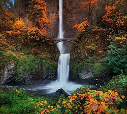 Multnomah Falls is located in the Colombian River Gorge and can be found in northwestern Oregon. Spanning two tiers on basalt cliffs, it is the tallest waterfall in the state at 620 feet or 189 meters. There are many travelers that consider the site, to be Americas most beautiful waterfall. It is the 27th stop in our travel series Off The Beaten Path.
 The White Pass and Yukon Railway links the port of Skagway, Alaska located in the United States and Whitehorse, the capital of the Canadian Territory of the Yukon. Normal commercial operations of the rail-line ceased in 1982, but was partially revived as a heritage railway in 1988.
 Fly Geyser in Nevada on the edge of Black Rock Desert, was an accidental creation in the search for geothermal energy. During a well drilling in 1964, water with dissolved minerals started rising out of the hole. After the excavation, either the boring was left unplugged or was not capped correctly. Over time a travertine mound was created, with the mineral laden water. The rocks would become covered in multiple hues of green and red. It is our 25th stop in the United States based travel series
 Instead, it has created an almost
 Darvaza Gas Crater located in the Karakum Desert of Turkmenistan, is one of the most unusual geological features one can visit in the world. The formation may have started burning as early as 1971.
 The calculation was reasonably considered, that the gas would burn off in a matter of weeks.
 Arches National Park contains the highest density of natural sandstone arches in the world. More than 2,000 of them can be found inside this American geological wonder. Located in eastern Utah, the park contains an incredible abundance of unique rock formations. It is our 24th stop in the United States based travel series
 Kaieteur Falls located in Guyana, is one of the most impressive jewels of nature, to be found in the Amazon. Although in total it comprises an impressive 822-foot high (251 meters) waterfall, it is also known to have the highest single drop in falls on the earth, at an incredible 741 feet. The journey to Kaieteur National Park in South America, is our 8th stop in the travel series
 The International Spy Museum in Washington D.C., houses the largest collection of international espionage artifacts on public display. The facility which opened in 2002, is dedicated to the trade craft and contemporary role of spying. The permanent aggregation, provides the complete history of espionage from ancient times, to the present day. It is the 23rd stop in the travel series

 RSS Feed
