|
The South Dakota School of Mines and Technology was founded in 1885. The historic focus of the institute, was on the area’s primary industry of mining. Over the subsequent years, it has evolved into one of the leading sciences and engineering universities in the region. The geologic and paleontological collections have grown over the years, to an incredible assemblage of over 500,000 individual specimens. Professor G.E. Bailey of Hill City provided over 5000 mineral and fossil samples, that formed the foundation for the Museum of Geology, which was founded the same year as the school. Construction of the Old Prep Building also began in 1885, as a place to house the artifacts that were being collected for the museum. In 1899, Dr. Cleophas C. O’Harra, the Professor of Geology and Mineralogy led the first school sponsored paleontology expedition into the Badlands of South Dakota. An alligator snout found on the trip became the first specimen curated into the museum paleontology collection.
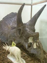
In 1923 the Museum of Geology opened to the public, attracting 4,000 visitors. The numbers would double the following year and reach 12,000 in 1925. Throughout the 1920’s a number of important fossils would be discovered in the field and put on display. This would include a nearly complete alligator sample, a large Xiphactinus (fish) skeleton and a Triceratops skull. In 1942, the Museum exhibits are relocated to the third floor of the newly completed O’Harra building. Two important additions to the paleontology collections were the 1945 discovery of a mosasaur fossil made by a schoolboy, and the 1949 detection of plesiosaur remains by a rancher. The latter half of the 20th century saw an expansion of the museum collections, through further excavations and donations. Further excavations would include camel skeletons and a tyrannosaurus skull. A notable donation came from the estate of Harold J. Cook in 1965. A large assortment of books, maps, fossils, minerals, and rocks came into the possession of the museum. A 1999, donation was made by Dr. Gail Bishop from Georgia Southern University. It contained a large collection of fossil decapods and associated archives.
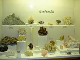
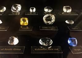
The Museum of Geology is the hidden jewel of the university. The mission of the institution has been to conserve the rich geological heritage of the state. The museum has collected, researched and organized rare and often unique artifacts. There are extensive exhibits that concentrate on paleontology. These include mounted dinosaurs, mammals, White River Badlands, marine reptiles and fish. The fossils are arranged in time specific dioramas. Also, on display are mineral collections including the Hall of South Dakota Minerals, meteorites, ores and a particularly popular fluorescent mineral room. Guests are able to learn about minerals, including gems, crystals and the rocks they form. A Kids’ Zone offers hands on experiences for younger visitors. There are even opportunities for summer field paleo classes. The James E. Martin Paleontology Research Laboratory is a 33,000 square foot facility, specifically built as a repository for the Museum of Geology collections and archives. The research activities in geology and paleontology conducted here, greatly enhance the mission of the museum to explore the natural history of Earth, through scientific inquiry. Unfortunately, the research laboratory is not open for public tours. Location The Museum of Geology in Rapid City, lies east of the Black Hills National Forest, in western South Dakota. It is known as a gateway to Mt. Rushmore. It is just south of Interstate 90. Rapid City is the second largest city in the state. The Museum is located on the 3rd floor of the O’Harra Building at the School of Mines and Technology. Address The Museum of Geology 501 East St. Joseph Street Rapid City, South Dakota 57701
Phone Number (605) 394-2467 Toll Free (800) 544 – 8162—–Extension 2467
Email: [email protected]
Website: museum.sdsmt.edu
Museum Admission Free
Days and Hours of Operations
Summer Season: May 01 through August 31. Monday through Saturday 9:00 AM. and 6:00 PM.
Winter Season: September 01 through April 30. Monday through Saturday 8:30 AM. and 4:00 PM.
Closed Sundays and all Federal recognized Holidays.
The Museum of Geology has full handicap access. Guided tours are available for groups if arranged in advance.
Gift Shop Offers unique books, toys, apparel, gifts, geology tools and museum guide books.
Lodging Is available in Rapid City, just a few minutes from the Geology Museum.
Helpful Hints
The post The Museum Of Geology: A Hidden Jewel In Rapid City, South Dakota appeared first on WanderingTrader. from http://wanderingtrader.com/travel-blog/united-states/the-museum-of-geology-a-hidden-jewel-in-rapid-city-south-dakota/
0 Comments
Geologic movement inside the volcanic crater of Dallol and the interaction between the volcanic minerals and the salt in the water, have raised the temperature in the vicinity to over 200 degrees Fahrenheit (100 Celsius). 
Danakil Depression Further away from the volcano, the temperatures are still extreme. They average by noon at 48 Celsius or 118 Fahrenheit. Barbara Cavalazzi from the University of Bologna in Italy, once measured a temperature of 55 degrees Celsius or 131 Fahrenheit. Along with the amazingly high temperatures of the area, the volcano and the nearby hydro-thermal fields, provide for the world’s lowest sub-volcanic region. It is 410 feet or 125 meters, below sea level. Danakil Depression has been called the “gateway to hell”. It is also referred to as the Afar Depression or Afar Triangle and is contained inside the Great Rift Valley of East Africa. It is the place where three continental tectonic plates meet. 
Great Rift Valley of East Africa As these huge plates move apart at a yearly pace of 1 to 2 centimeters (0.39 to 0.78 inches), new crust is being formed, creating various types of faults and fissures. It results in large lava lakes, that light up the night sky. The subsequent thermal action provides the conditions necessary for geysers and hot springs. Discharges of brine and acidic liquid produce numerous cones of salt deposits and significant bodies of potash. The Danakil waters have an average pH of 0.2, which is almost unheard of in any natural setting. Located in the Horn of Africa, the Danakil Depression and the Dallol Volcano, are one of the most remote, inhospitable and least studied locations, in the entire world. Dallol was formed by the intrusion of basaltic magma into Miocene salt deposits and the subsequent hydro-thermal movement. Magma steam blasts took place in 1926, which formed Dallol Volcano, but numerous other eruption craters can be found nearby. The 1926 event, produced a 30 meter (98.4 feet) wide crater at the foot of the Black Mountain. In October 2004, the shallow magma chamber beneath Dallol deflated, which fed a magma intrusion heading southwards beneath the rift. Another major eruption occurred in January 2011. Dallol is a term used by the local Afar people, meaning disintegration and dissolution. It describes a landscape of green acid ponds, iron oxide, sulfur, and salt desert plains. Although some enthusiasts have described Dallol and the surrounding area to Yellowstone National Park in the United States, the Danakil Depression has a far more varied and completely unique landscape. The Dallol volcano which is actually a hydro-thermal field in its entirety, accounts for the unusual structures formed in a complex interaction of solution and re-crystallization, driven by processes, of hydro-thermal waters and rapid evaporation.
As one of the driest places on the earth, it receives just 100 to 200mm (3.9 to 7.8 inches) a year of precipitation so therefore, vegetative growth is quite limited. The hot and dry climate of the area, means that just a few plants or animals, can actually survive there. Although the Dallol site itself is unpopulated, the nomadic Afar people, have settled nearby in a semi-permanent village called Hamadela. Since 2013, teams of scientists from Europlanet, a consortium of companies and research institutions have begun studies of the region to investigate how life might evolve on other planets. It may well serve as analogues, for a future trip to Mars. The hot springs in the Depression are home to microorganisms called extremophiles, which by its very name, suggests extreme conditions. Tourists to the area will need to contend with a number of issues. Along with the sweltering heat, the closer you get to the volcano the more you need to be concerned with the poisonous gases being released from the ground. These would include hydrogen sulphide and chlorine. One would need to wear gas masks at this point.
The closest hospital is in Mekelle which is far away, from the Dallol crater. Another concern is the present security situation. Located near the border of Ethiopia and Eritrea, one needs to be mindful of the political situation. The researchers that come to the area, are accompanied by armed men, for their own protection. This writer recommends you also visit Erta Ale. A shield volcano, it is the most active volcano in Ethiopia, located nearby Dallol, (a distance of 80.7 kilometers or 50 miles). It is one of only six lava lakes, globally. Of course, this will necessitate, that you spend at least one-night camping in the Danakil Depression. 
Erta Ale volcano in Ethiopia Erta Ale will light up the night sky, which can be seen from miles away. It is interesting to note that in 1974, Donald Johanson and his colleagues, found the now internationally celebrated Australopithecus remnant known as “Lucy” in this region. Many other fossils of early hominis have been uncovered in the Danakil Depression. It has led to a number of paleontologists to theorize; the area may be where our species first evolved. This has resulted in an additional name for the area “cradle of humanity”. Location Dallol volcano is located 122 kilometers or 75.8 miles from Mekelle. It will require driving for quite some time, on bumpy dusty dirt roads, that will not be in good condition. It takes you from the highlands of Ethiopia, where Mekelle is located, to the low-lying desert of the Danakil Depression. Admission There is no official admission to the Crater, but the local cost of your trip which will be either one day, a number of days to a week and will range from $500.00 to $1000.00 USD (United States Dollar). Tours Travelers, will need to book a trip, with a local tourist company. These companies often employ individuals that have armed forces experience, to keep you safe on your trip. Days and Time of Operations It is available for viewing according to the schedule provided by the travel companies and local guides, throughout the calendar year. The same day trip will be from 4:00 am to 4:00 pm. The multi-day tours, will typically arrive at your lodge at 8:00 am. Lodging Is available in Mekelle upon your arrival. You will be camping out for a number of days for the typical trip. Valuable Tips
The post Other Worldly Dallol Volcano Of Ethiopia In The Danakil Depression appeared first on WanderingTrader. from http://wanderingtrader.com/travel-blog/other-worldly-dallol-volcano-of-ethiopia-in-the-danakil-depression/ 
Water running down the cascades, a colored picture before 1903. Bergpark Wilhelmshohe is the largest hillside park in Europe and can be found in Kassel, Germany. At 590 acres (2.4 square kilometers), the historical tract is the second largest hill slope park in the world. Beginning in 1689, the project would take a full 150 years to complete. Commissioned by the Landgraves of Hesse-Kassel, the park became a World Heritage Site in 2013. Bergpark Wilhelmshohe is the 13th stop, in the ongoing series A World Far And Away. Begun by Landgrave Carl of Hesse-Kassel, the Bergpark (mountain park) Wilhelmshohe, was constructed on an east to west axis, which would continue to develop and expand into the 19th century. The original ensemble of the Bergpark, was an outstanding demonstration of man’s mastery over nature. It also provided a magnificent panoramic view, of the city of Kassel. The original Baroque design of the Italian and French formal gardens would be later re-arranged into an English landscape garden. The enlargement was to create more naturalized gardens in the late 1700’s. This change in style, explains the small ponds and secluded enchanting areas, that can now be found throughout the park. 
Great Fountain The 18th century additions engineered by Carl’s great-grandson, the Elector Wilhelm I, constitute an expression of ideals and aesthetics, that were being promoted in garden design, during the growing Romantic movement. These idealistic emotions and feelings, would peak during the first half of the 1800’s. In 1785, the Elector was said to have inherited, one of the largest fortunes in Europe, at the time. This massive wealth was already being well managed by family of Rothschild. The money accumulated from these estates, provided ample financial resources, for the expansion of the Bergpark gardens. 
Wilhelmshohe Palace The following year, the Elector had his architect design the neoclassical palace of Schloss Wilhelmshohe. Later in history, William II, the King of Prussia and the last German Emperor, would use the former Elector’s abode, as his summer residence. Today, the palace houses an Old Masters Gallery, which focuses on the 16th and 17th centuries, containing masterpieces by German, Italian, French and Spanish painters. The well known “The Man with the Slouch Hat” by Frans Hals are among them. 
The Lion Castle The assemblage includes paintings by Rembrandt, the second largest collection from the artist in all of Germany. Rembrandt’s famous “Saskia” can be found here. There is also an aggregation of Greco-Roman antiquities and the Weissenstein Museum. The Lowenburg (the Lion Castle) within the same park was built in 1793, for the Elector and his mistress. The building became his place of personal retreat. He is buried in a crypt under the castle’s chapel. 
The Hercules – the Kassel landmark. Lion Castle comes complete with medieval features like a moat and a drawbridge. The interior contains authentic Middle Ages fixtures and numbers of rare and unique artifacts. As one of the most impressive Baroque parks globally, the Bergpark Wilhelmshohe contains numerous unique landscape architectural monuments. Among the most noteworthy, is a Roman aqueduct, with a 141 feet (43 meters) high artificial waterfall. The water cascades down the hill for over 1148 feet or 350 meters. Above the falls, the most popular site within the Bergpark is the 231 (70.5 meters) high Hercules Monument. A statue of the demigod stands on top of a pyramid, which is on top of an octagon. There are more than 200 steps, leading to the top. 
Close-up of Hercules monument, Kassel Construction of Hercules Monument was begun in 1701 and finished in 1717 by a design from the Italian architect Giovanni, Francesco Guerniero. It was artistically and technically, the most colossal and sophisticated statue of the Early Modern Era. The solid copper 27 foot (8.25 meter) statue of Hercules itself, can still be seen, from many miles away. Reservoirs and channels behind the Hercules Monument, have been designed to supply water for an intricate system of hydro-pneumatic devices. These are all employed in creation of the large Baroque water theater, grotto, fountains, and the aforementioned, Grand Cascade. 
Devil’s Bridge Waterfall The whole system relies on natural pressure from reservoirs and underground pipes, whose locks are opened manually. It has been in operation for over 300 years. Other waterways feed a provide for a series of dramatic waterfalls and wild rapids. Another major focal point is the almost geyser like Great Fountain, which propels water up to 164 feet (50 meters) high. Built in 1767, it was known as the tallest fountain in the world, at the time. Additional channels of water lead to a number of secluded ponds and a lake. The Bergpark Wilhelmshohe, contains over 600 different types of trees. 
Cascades in the evening hours, During the summer from May until October every Wednesday and Sunday afternoon, visitors can attend the main water features event. Every time about 92,000 gallons (350,000 liters) of water are needed. Tourists can follow the water’s path downward, from the Hercules Monument via the Vexing Grotto and Artichoke Basin with their marvelous acoustic effects, onto Felsensturz Waterfall and Giant’s Head Basin. The water then runs down the Baroque Cascades, the Steinhofer’s Waterfall, and the devil’s bridge, until it tumbles down the aqueduct before arriving at Neptune’s Basin before the lake. This is next to the castle of Wilhelmshohe, where the Great Fountain ends this wondrous presentation. 
Steinhofer’s Waterfall Additionally, every first Saturday of the months, of June, July, August and September, the same event takes place in the evening. There are lights of various colors illuminating from the water, the fountain and the different monuments. These water based displays, are just simply magical. Schloss Wilhelmshohe was damaged by Allied bombs during World War II. It was refurbished into an art museum from 1968 to 1974. No extensions were made to the park in the 20th century, so most of the grounds look like they did in the 1800’s Location Kassel, Hesse, Germany Bad Wilhelmshohe a Stadtteil of Kassel in Northern Hesse. Situated west of the city center, at the foot of the Habichtswald hill range. Address: Bergpark Wilhelmshohe, Schlosspark 1, 34131 Kassel, Germany Phone: +49 561 31680123 Fax: 0561 31680-111 Email– info[at]museum-kassel.de Getting There At the Kassel-Wilhelmshohe station on the Hanover-Wurzburg high speed rail-line. Admission Bergpark Wilhelmshohe is free of charge. Hercules Monument and Octagon (platform and Pyramid) 3 Euros or $3.40 USD (United States Dollar) – children and those under 18 are free Wilhelmshohe Palace: 6 Euros ($6.80 USD) with a reduced rate of 4 Euros ($4.54 USD)- children and those under 18 are free. Audio guide available for Old Masters Picture Gallery and the Antiquities Collection (German/English) 3 Euros Lowenburg Castle including tour 2 Euros ($2.27 USD) – reduced 1 Euro ($1.13 USD) – children and those under 18 are free. Days and Hours of Operations Bergpark Wilhelmshohe is open all year. Visitor Center Wilhelmshohe: April 01 – October 31—-Tuesday – Sunday 10:00 am – 5:00 pm November 01 – March 31: Friday – Sunday and public holidays 10:00 am – 4:00 pm Visitor Center Hercules–Tuesday – Sunday and public holidays 10 am – 5 pm Hercules Monument and Octagon (platform and Pyramid) April 01 – October 31 Tuesday – Sunday and public holidays 10 am – 5 pm Tickets are available until 4:20 pm, last entrance 4:30 pm. Subject to weather-related changes. Closed during winter months. Wilhelmshohe Palace: Tuesday – Sunday and public holidays 10:00 am – 5 pm Wednesday until 8 pm. There are a number of other attractions on the site, that are open for similar days and hours. Lowenburg Castle: April 01 – October 31 Tuesday – Sunday and public holidays 10:00 am – 5:00 pm (last tour at 4:00 pm) November 01 to March 31 Friday – Sunday and public holidays 10:00 am – 4:00 pm (last tour at 3:00 pm) At present there is a large-scale restoration in progress, so only the Armory and the Chapel are open to visitors. Ticket prices have been reduced as a result. Lodging Is available throughout the city of Kassel. Valuable Tips
The post Historical Bergpark Wilhelmshohe of Kassel Germany, Europe’s Largest Hillside Park appeared first on WanderingTrader. from http://wanderingtrader.com/travel-blog/historical-bergpark-wilhelmshohe-of-kassel-germany-europes-largest-hillside-park/
The luminescence of Mosquito Bay is caused by a microorganism, the dinoflagellate which creates a glow in the water, when it is disturbed. It leaves a near supernatural trail of neon blue, as one passes. Other famous locations for bioluminescent bays are in Jamaica, the Maldives and Vietnam. 
Vieques from the air, looking west. As part of the island group referred to as the Spanish Virgin Islands, Vieques can be found 8 miles (13 kilometers) east of the Puerto Rican mainland. The island itself, measures 20 miles (32 kilometers) long and 4.5 ( kilometers) miles wide. Vieques beaches have been identified, as among the top 25 best in the world. Along with snorkeling, and a number of archaeological sites, including a museum, what sets the island apart, is the presence of two pristine bioluminescent bays, with Mosquito Bay being the most spectacular. Specific conditions must exist for bioluminescence, which includes a complete lack of modern development, which is clearly the case around Mosquito Bay.
In 2008, the Guinness Book of World Records declared Mosquito Bay, as having the brightest recorded bioluminescent water, anywhere in the world. The water must also be cool and deep enough, with only a small channel, connecting the bay to the ocean. This provides some protection for the dinoflagellate, from the more vigorous wave action outside the bay. 
Bahía del Corcho(Cork Bay) aka Playa Caracas(Caracas Beach) also called Red Beach It must be noted that the channel itself, is an artificial creation. Early Spanish explorers wanted to choke the bay off from the ocean. To achieve this end, they dropped huge boulders in the channel. This was due to the fact, that they believed the bioluminescence they encountered, was an act of evil and could be attributed to the devil. In reality, they actually enhanced conditions for the bioluminescence. By isolating the bay, even further, the Spanish preserved the area and helped increase the numbers of dinoflagellate. In the case of Mosquito Bay, red mangrove trees surround the water. It is not necessary to the survival of the species, but seems to enhance their abundance.
It is the result of the proper salt concentration of the water and the mangrove roots. This combination provides the ideal environment, providing both food and protection to the microorganisms. One historical anomaly, that contributed to the lack of development on the island, was the fact that for sixty years, the majority of Vieques was controlled by the United States Navy. This has been a boon for travelers, looking for a place that is absent of traffic noise and the bustle of cities. To view this amazing sight, one will need to employ the services of a tour guide. This travel writer recommends contacting a company that uses glass bottom kayaks, which will magnify your experience. The paddle of the kayak will create a trail of luminescent blue, as it continues to break through the water. The fish that swim in the bay, will look like they are glowing from the kayaks. To fully appreciate the outing, be sure to dip your hand in the water and watch it shimmer. The best time for viewing Mosquito Bay is during a “New Moon” phase. Getting There Located on the southern shore of Vieques, Mosquito Bay can be reached by ferry from Fajardo, on the main island of Puerto Rico. Tour companies typically provide transportation to the bay, from the island town of Esperanza. Arranging A Tour Although there are a number of tours available, it is better to go with a firm that provides for smaller groups, of only 6 to 8 participants. This will allow you to better appreciate, the natural beauty of the bay. Tours usually do not operate the day before, during and after the full moon, since the luminescence of the bay, will be muted. Entrance Fee The cost of the tours will average between $35.00 to $55.00 USD (United States Dollar) for adults and $20.00 to $25.00 USD for children, aged 6 to 11. Days and Hours of Day Operations Tours take place throughout the year upon nightfall and continue well into the night. Most tour companies operate Monday through Saturday. Winter time tours run earlier from 6:00 pm to 11:00 pm. Tours run for about 2 hours, including the transfer to the bay and back. Accommodation Night time tours will require travelers to remain on the island, at least overnight. Tour companies are usually more than willing, to provide suggestions for hotels or guest houses. Helpful Hints
The post A Natural Wonder: Bioluminescent Mosquito Bay In Vieques, Puerto Rico appeared first on WanderingTrader. from http://wanderingtrader.com/travel-blog/united-states/a-natural-wonder-bioluminescent-mosquito-bay-in-vieques-puerto-rico/
The Chilean Museum of Pre-Colombian Art is dedicated to the display and further study of artifacts from Latin America. Part of the mission of the museum, is to further research the art created by these earlier indigenous people, as a basis for understanding the wider culture. The concept remains a pioneering and unique initiative, in the Americas. The museum known locally as the Museo Chileno de Arte Precolombino, was founded by the Chilean architect Sergio Larrain Garcia-Moreno. Over the course of fifty years, Garcia-Moreno as an antiquities collector, was able to amass an impressive private collection of Pre-Colombian art. 
Sergio Larrain Garcia-Moreno. Garcia-Moreno based his acquisitions of historical art, more on the thoughtful and spiritual message they conveyed, rather than simple accumulation. His belief was the art of these early people, contained a hidden message to all of humanity, of a cultural uniqueness that had to be uncovered and preserved. During the 1970’s, Garcia-Moreno began seeking a permanent site, for the display and preservation of his near mythical assemblage of native art. He approached both governmental and university institutions with the intention of donating the collection. His earlier attempts led to failure. The Chilean capital of Santiago, remained an ideal location, to place a historical art museum. With the support of the city government from then mayor Patricio Mekis, Garcia-Moreno was able to secure the impressive Palacio de la Real Aduana. 
Palacio de la Real Aduana The Palacio de la Real Aduana itself, was built in a neoclassical style, between 1805 and 1807. It was constructed by use of the plans, provided by Italian architect Joaquin Toesca. The building had been used by the Spanish colonial government as a Royal Customs House. It had already been identified as a National Monument, before it was decided to use the space to house the Garcia-Moreno collection. The site of the Palacio de la Real Aduana, has played a prominent role in the history of Chile. In 1555, the land was granted to Juan de Cuevas, the very first mayor of Chile. He decided to build his residence there. In 1635, the Jesuit Order installed the royal Colegio Convictorio de San Francisco Javier, after named the Convictorio Carolina de Nobles. After independence in the 1820’s the Palacio de la Real Aduana housed the National Library. In 1845, it became the home for the Courts of Justice. In 1968, a fire not only destroyed the archives, but the building itself. Through a series of restoration projects in the 1980’s, the Palacio de la Real Aduana was completely rebuilt and refurbished. A major challenge for Garcia-Moreno, was how best to legally transfer title of his archaeological collection, to an institution that would maintain his standards and principles associated with art. Julio Philippi, a prominent Chilean lawyer, subsequently created the legal framework, where the family of Garcia-Moreno would be donating the art pieces through a foundation, to the newly established museum.
Upon finalization of the agreement, later in December 1981, the Chilean Museum of Pre-Colombian Art opened its doors, to the public at large. It would close in 2011, for further renovation, but re-opened in 2013. The varying pieces of art in the collection, draw upon all the major Pre-Colombian culture areas of Meso-America, Intermemdiate/Isthmo-Colombian, Pan-Caribbean, Amazonian, and Andean. The later includes both the central and southern Andes. 
Pre-Colombian Pottery The more than 3,000 pieces in the museum, represent over 100 different groups of people, over a span of 10,000 years. The collection itself, is divided up into four main groupings. These are Meso-America, Intermedia, Andes Centrales,and Andes del Sur. The Meso-America area contains items from the Aztec, the Mayan and Teotihuacan civilizations. This area includes the modern day nations of Mexico, Guatemala, Honduras, El Salvador, and part of Nicaragua. Intermedia includes the countries of Colombia and Ecuador. On display is pottery from the Valdivia, Capuli figures, and a number of gold objects from the Diquis and Veraguas.
Area Andes del Sur features more modern Argentinian and Chilean artifacts. There are ceramic urns from the Aquada people, items from the San Pedro culture, and even Incan quipu. In addition, the museum contains some of the world’s oldest known mummies. Garcia-Moreno with his dream realized, would pass away at the end of the 20th century, in 1999. He leaves behind an incredible collection of historical art that future generations will be able to view and enjoy. Location Address: Bandera 361, corner Company. Santiago, Chile. Zip code: 8320298 Phone: (56) 2 29281500 Email- [email protected] Website: http://www.precolombino.cl/ Getting There Metro: Plaza de Armas, line 5 University of Chile, line 1 Admission Adult rate for Chilean and foreign resident tickets is $1,000 ($1.49 USD) United States Dollar Foreigners $6,000 ($8.92 USD) Chilean students $500 ($0.74 USD) Foreign Students $3,000 ($4.46 USD) Children under 10 are admitted free Indigenous people are admitted free Children and young adults in the school system, admitted free On the first Sunday of each month: There is no entrance fee. Days and Hours of Operations Monday: Closed Tuesday: 10 a.m. to 18:00 (6:00 p.m.) Wednesday 10:00 a.m. to 18:00 (6:00 p.m.) Thursday: 10:00 a.m. to 18:00 (6:00 p.m.) Friday: 10:00 a.m. to 18:00 (6:00 p.m.) Saturday: 10:00 a.m. to 18:00 (6:00 p.m.) Sunday: 10:00 a.m. to 18:00 (4:00 p.m.) You will need to enter the museum, before 5:30 p.m. The museum will be closed on the following days: January 01 March 30 May 01 September 18 & 19 December 25 Audio Guides: http://www.precolombino.cl/planifica-tu-visita/audioguias/ Visitors can download audio guides, with the texts of the permanent exhibition cases. They are ordered by cultural areas, according to the normal tour of the exhibition halls. The audio guides are in mp3 format and are available in English, Spanish, French and Portuguese. The Museum Gift Shop/Store offers a wide range of further information on Pre-Colombian People in the Americas. There are a number of replicas of Pre-Colombian artifacts, along with indigenous crafts, books, bags, postcards etc. Cafe & Restaurant Pre-Colombian Coffee by Blue Jar Hours: Monday through Friday 8:30 a.m. to 17:00 (5:00 p.m.) Saturday and Sunday and public holidays 10:00 a.m. to 5:00 p.m. Telephone: (56) 2 32013622 Lodging Is available throughout the city of Santiago. Valuable Tips
The post The Mythical Chilean Museum of Pre-Colombian Art in Santiago appeared first on WanderingTrader. from http://wanderingtrader.com/travel-blog/the-mythical-chilean-museum-of-pre-colombian-art-in-santiago/
The National Geographic magazine published a list of the 16 best history museums in the world, the Museum of Gold, came in ninth place. The El Museo del Oro houses the most important collections of pre-Hispanic metallurgy globally. 
Pectoral Tolima culture The Gold Museum has on display throughout the second and third floors, an incredible selection of pre-Colombian (before the Spanish conquest) gold and other metal alloys artifacts, that rival and surpass, the collections of other renowned sites. The full assortment contains a total of 55,000 pieces, of which 6,000 are on display in the expanded facility, following a renovation in 2008. The texts of the permanent exhibitions are provided in both Spanish and in English. 
The Quimbaya Poporo, The history of the Museum of Gold can be traced back to 1934. It was when The Bank of the Republic (Central Bank of Colombia) began to assist in the protection of the archaeological treasures of Colombia. The first item in the now celebrated collection was the Poporo Quimbaya. It is a ceremonial apparatus used for chewing coca leaves, during religious ceremonies. It was created around 300 C.E. by employing the method known as lost wax casting. The Poporo Quimbaya is made of an alloy of copper and gold, that the Spanish have identified as tumbaga. It is now one of the most recognized pre-Colombian art pieces. It even has been depicted on Colombia’s currency. This now famous artifact is believed to have been stolen from a burial chamber during the 1930’s. The location is thought to be on Loma del Pajarito “Birdie Hill” in Yarumal, of the Antioquia department of Colombia. 
Golden mask Grave robbing of indigenous burial sites, was a common occurrence back then. It often had the unfortunate consequence, of the destruction of other important archaeological artifacts and valuable information, in the pursuit of gold and other precious metals and gems. To preserve it from destruction or have it leave the country to be sold abroad, the central bank purchased the Poporo Quimbaya. This soon led to a far larger project, for the preservation of similar objects of interest and historical value for the nation. To house the growing collection, made through purchases by the bank, the decision was made in 1939, to establish the El Museo del Oro. This allowed items bought by the institution, to go on public display, with some items like the Poporo Quimbaya being viewed for close to 80 years. 
Muisca Golden Raft In addition, to the gold and metal alloy artifacts, there is a wide variety of other objects made by indigenous cultures that pre-date the arrival of the Europeans. These include pottery, items made from shell, stone and wood, as well as textiles. The Gold Museum also houses the legendary Muisca Golden Raft. Discovered in 1969, it represents the ceremony of the new zipa (ruler) of Bacata. It forms part of the basis of the once international sought myth of El Dorado ( the city of gold). The Golden Raft illustrates the transition of power, as the new ruler assumes his position amidst a offering to the gods. He is surrounded by other chieftains, all decorated with gold and feathers. The major renovation that took place a decade ago, organized the permanent exhibition in five rather large rooms. These are where tourists will find the most important objects on display and an interactive room. The reconstruction plan has also allowed for the addition of an auditorium, a cafe, a restaurant, souvenir gift shop and some temporary exhibition rooms.
The permanent exhibition is divided into different corridors for each distinctive culture for a total of 13. These are the Calima, Cauca, Chocó, Malagana, Muisca, Nariño, Quimbaya, San Agustin, Tairona, Tierraadentro, Tolima, Tumaco, Uraba and Zenu. There is also a special room identified as Despues de Colon (After Columbus). The exposition continues on the third floor. There is The Flying Chamanic which shows the process of a shamanic ceremony, with its assortment of gold pieces. Another grouping is The Offering, which is divided into three parts. These are the “Offering Room”, the “Offering Boat” and the “Lake”. At the end of the exposition one can find a “Profunditation Room”. It contains artistic videos of the most important gold pieces found in the Gold Museum. On the fourth floor is located the Exploratory, a room that promotes interactivity and reflection around the diversity and meaning of the heritage, that the Gold Museum preserves. Location Address: Cra. 6 # 15-88 Bogota, Colombia The Gold Museum is located on the Parque de Santander, on the corner between Carrera 6 and Calle 16. Phone: (571) 3432222 Fax: (+90) – 256 – 6127244 Email— [email protected] Website: www.banrepcultural.org/bogota/museo-del-oro Getting There Coming from abroad, you would arrive at the Bogota Airport Take public transport or rent a car to the Museum The Museum of Gold offers free parking for two hours, but space is limited. Admission Adult rate is COP $4,000 ($1.27 USD) United States Dollar (Tuesday through Saturday). Sundays: There is no entrance fee. Holiday season: COP $4,000 ($1.27 USD) Free entrance to those visitors who are under 12 and over 60. You will need to obtain a ticket, even if your admission is considered free. At the box office on the first floor, you will be offered audio guides in the following languages: Spanish, English, French and Portuguese. This will permit the visitor to view the artifacts at their own leisure. The rental price will be COP $8,000 ($2.55 USD) The Gold Museum does offer free guided tours at certain times. The tours will last about 1:30 hours. Tours Tuesday – Friday In Spanish 11:00 a.m. 3:00 & 4:00 p.m. Tuesday – Friday In English 11:00 a.m. 4:00 p.m. Saturdays: In Spanish 10:00 & 11:00 a.m. 3:00 & 4:00 p.m. Saturdays In English 11:00 a.m. 4:00 p.m. Days and Hours of Operations Monday: Closed Tuesday: 9:00 a.m. to 18:00 (6:00 p.m.) Wednesday 9:00 a.m. to 18:00 (6:00 p.m.) Thursday: 9:00 a.m. to 18:00 (6:00 p.m.) Friday: 9:00 a.m. to 18:00 (6:00 p.m.) Saturday: 9:00 a.m. to 18:00 (6:00 p.m.) Sunday: 9:00 a.m. to 16:00 (4:00 p.m.) You will be expected to exit the museum, at least an hour after the closure time. Will be closed on major holidays and election days. Lodging Is available throughout the city of Bogota. Valuable Tips
The post The Fabulous Museum Of Gold (El Museo del Oro) In Bogota, Colombia appeared first on WanderingTrader. from http://wanderingtrader.com/travel-blog/the-fabulous-museum-of-gold-el-museo-del-oro-in-bogota-colombia/
The W.A. Clark Mansion was added to the National Register of Historic Places in 1970. As the home of one of the three copper mining barons of the state, the residence played a role in the development of the regions economy. The Copper King Mansion did undergo restoration work in 2012. The mansion consists of 34 rooms and was built in the Romanesque Revival Style, that had become quite popular in the Gilded Age. The building contains fresco painted ceilings, stained glass windows by Tiffany and ornamented hand carved fireplaces. There are ornately designed parquets of rare imported wood and elegant gilded staircases. One can find both gas and electric chandeliers in abundance, throughout the mansion. Clark did incorporate the most modern household inventions, that were available at the time. 
Stained glass,& grand staircase. Construction came under the direction of D.T. McDevitt. The woodwork was the responsibility of W.F. Beall & Co. from Chicago. There are numerous panels of bird’s-eye maple, Cuban mahogany, fine oak, rosewood and sycamore. Plaster was painted with swirls of gold in the entryway, bronze in the octagonal reception room, silver in the dining room and copper in the billiard room. The mansion is elaborately furnished with period antiques and furniture, with colorful oriental rugs. The embellishments and many of the materials for the mansion were all imported at an enormous cost of $200,000 USD (United States Dollar). This would be the equivalent of $5 million USD today. William Andrews Clark supervised every detail in the building of his red-brick Victorian mansion. As one of the wealthiest men in Montana, William Andrews Clark built the mansion as a symbol of his wealth and power within the community. He and two other fellow industrialists, Augustus Heinze and Marcus Daly, were in a bitter ongoing competition, for control of the regions rich copper resources. 
William Andrews Clark Clark supposedly was born in a log house in the state of Pennsylvania during the spring of 1839. The family would later move to Iowa in 1856. In 1862, during the American Civil War, he traveled further west to become a miner. After working in the quartz mines in Colorado, he proceeded north the following year. He had been tempted to participate in the Montana Gold Rush. Settling in the capital of the territory, his gold claim only paid moderate returns. Clark invested those in becoming a trader. He hired mules to move supplies between the booming mining communities of Montana and the city of Las Vegas. Within a short time he would change his vocation, and would become a banker in Deer Lodge Montana. He began to repossess mining properties,when owners defaulted on their loans. Clark over time, became a major power in the Montana mining industry. 
W. A. Clark buying a newspaper, circa 1906. As the years passed, Clark amassed a fortune in mining, small smelters, electric power companies, newspapers and railroads. As part of his transportation empire, he bought and then developed a watering stop that would grow into the city of Las Vegas. The surrounding jurisdiction, was fittingly named Clark County. He is also largely responsible for the selection of Helena, as the political capital of Montana. William Andrews Clark could now dream about a future in politics. He served as president of both Montana state constitutional conventions in 1884 and 1889. His dream of becoming a United States Senator was first realized in 1899, but resulted in a massive scandal. It was later revealed he had actually bribed members of the Montana State Legislature, so they would cast a vote for him. 
Political cartoon depicting Clark bribing state legislators, October 1900 At the time, United States Senators were chosen by their respective state legislatures. The obvious corruption of this election and a number of others would soon change history, with the later passage of the 17th Amendment. Henceforth, Senators would be voted for by popular vote. Since the other Senators refuse to seat Clark, he was forced from office, the following year. It was a major setback for Clark. He is reported to have said in response to the scandal, I never bought a man who wasn’t for sale. After three more bitter campaigns for the Senate he was at last successful, and was able to serve one term from 1901 to 1907. At the time of his death in 1925, at the age of 86, Clark had amassed a fortune of between $150 to $300 million. At just $200 million, it is the equivalent of close to $2.9 billion in the currency of today. This made him one of the wealthiest Americans, to have ever lived. 
W. A. Clark Mansion in New York City. The mansion that he had built in New York City, sited directly across from Central Park on 5th Avenue, is considered by architectural historians, as the most expensive private home ever constructed in the city. Unfortunately, this fabulous residence would be demolished in 1927. His other residence, the Copper King Mansion came into possession of the Cote family in 1953. Privately owned, the mansion now serves as a bed and breakfast, operated by the Cote clan. The 5 rooms and suites available for lodging are elaborately decorated with period antiques,oriental rugs and rather dark woodwork. 3 rooms share a bathroom and the 2 suites feature sitting areas and private facilities with claw foot tubs. 
Dining room Guided tours have become available during the summer tourist season. Winter tours are accessible by appointment only. Location Copper King Mansion can be found in the downtown area, less than a mile from Montana Tech of the University of Montana Campus and 2 miles from the Big Butte Open Space Recreation Area. Arranging A Tour 1-(406)-782-7589 or by e-mail: the [email protected] To request a reservation for accommodation 1- (406) -782-7580 Address 219 West Granite Street Butte, Montana 59701, USA Website: thecopperkingmansion.com Entrance Fee The cost of an adult tour is $10.00 USD. For a children is $5.00 USD. If you are staying overnight at the mansion, the tour is provided free of charge, Days and Hours of Park Operations Guided Tours are provided from May 01 though September 30th Appointments are required during winter months. Please try to provide 24 hours notice ahead of a tour. Tours go through all bed and breakfast rooms, from 10:00 am to 4:00 pm. Tours are held at 10:00 am, noon, 2:00 pm and 3:30 pm. Prices for Overnight Accommodation https://copperkingmansion.squarespace.com/bed-and-breakfast-rooms-rates/ https://availabilityonline.com/availtable.php?un=copperkingmansion Master Bedroom Suite (private bathroom) $150.00 USD Family Suite (up to 4 guests) (private bathroom) $150.00 USD Huguettes’s Room $135.00 USD Andree’s Room $125.00 USD Butler Room $105.00 USD * There is a 7% State Bed Tax, that is added to the cost of your accommodation. Amenities Provided
Helpful Hints
The post The Copper King Mansion, W.A. Clark Mansion, In Butte Montana appeared first on WanderingTrader. from http://wanderingtrader.com/travel-blog/united-states/copper-king-mansion-w-clark-mansion-butte-montana/
Pamukkale has been famous as a destination, as a natural wonder for well over two millennium. The modern designation in Turkish means cotton castle. The carbonate minerals in the thermal waters, is what has created this magical site. It is our 13th stop in the series Journeys to Discovery. The calcite over time created an almost supernatural landscape, made up of mineral forests, petrified waterfalls and a series of terraced basins. There is a variation of color to the formations, which adds to the beauty of the place. As of 1997, to keep the travertine white and to prevent further damage, it is forbidden to walk over the formations at large. However, one can still walk on the south part of the springs barefoot. 
Greco-Roman ruins of Hierapolis Although overshadowed by the natural beauty of the springs and the resulting formations, Pamukkale also has well preserved Roman ruins ( the city of Hierapolis) and a noteworthy museum. Hierapolis meaning Holy City is an archeological museum itself. In ancient times, the hot springs were used to create a spa. Credit for this is given to the dynasty of the Attalids, the kings of Pergamon. Originally, the site was utilized by an ancient cult and would then later be used for scouring and drying wool. The Hellenistic city was built on a grid pattern with the streets running parallel or perpendicular to the main thoroughfare, with the main street running north to south, to a cliff with the travertine terraces. It would eventually reach about 4,900 feet (1,500 meters) long and 44 feet (13.5 meters) wide. The avenue was bordered on both sides by an arcade. Later in history, on both ends of the main street, a monumental gate flanked by square towers, would be built, with massive blocks of stone. In 133 BCE when King Attlaus III died, he left his kingdom to Rome. Therefore, Hierapolis would now become part of the Roman province of Asia. Since the second century BCE, countless patrons have sought out the healing waters. Many others would decide to retire there and make the area their new home. 
Tomb at the Necropolis Proof of the latter can be found in the large necropolis, filled with sarcophagi. One of the most famous remains, belong to the Roman, Marcus Aurelius Ammianos. The great baths built in Hierapolis were constructed with mammoth stone blocks, without the use of cement. These consisted of various closed and open sections, linked collectively. The deep recesses in the most inner section, include a bath, gymnasium and library. In Roman times, Hierapolis became a huge healing center, where physicians used the thermal springs as a therapy for their now countless patients. 
Ruins of the Roman Baths The architectural remnants that can be viewed today, are those that were constructed after the massive earthquake in 60 CE, that left the previous city in ruins. The rebuilding would be restored in a true Roman style, with imperial government support. During the reign of Roman Emperor Hadrian, in 129 CE, the rather large theater would be built. It would be further renovated during the reign of Emperor Severus, who reigned from 193 to 211 CE. When Emperor Caracalla visited the town in 215 CE, he conferred the much coveted title of special privilege known as neocoros, upon the community. This act would usher in the Golden Age of Hierapolis, as the city became one of the most prominent urban centers in the fields of the arts, philosophy and trade. 
Roman Theater During these years new building projects were started, including two new Roman baths, a gymnasium, a number of temples, a main avenue with a colonnade and a fountain at the hot spring. The population grew enormously during this period to around 100,000 inhabitants, as Hierapolis grew wealthier. The last imperial visit by a Roman Emperor would take place during the reign of Valens, signaling the end of an era and the changing fortunes of the city. As part of the Eastern Roman Empire or the Byzantine Empire, Hierapolis continued to flourish. 
Pluto’s Gate Various religions of the Classical Age were now being replaced by Christianity. Evidence of this, is provided with the filling up with stones, of Pluto’s Gate during the 4th century. Pluto’s Gate was sanctuary that had been built in honor of the Roman god Pluto, known in the Greek world as Hades. It was located in a cave, that emitted toxic gases and was considered to represent a gateway to the underworld. The famous Roman baths would now be transformed into a Christian basilica during this period and the Byzantine Emperor Justinian, would elevate the Bishop of Hierapolis to rank of metropolitan in 531 CE.
As the Byzantine Empire shrank in size, Hierapolis had the misfortune of being close to the frontier, so it fell under attack and changed political hands, a number of times. In the 12th century the region would fall under control of the Seljuk Sultanate of Konya. The Seljuks were a Turkish people with Persian influence. 
Frederick Barbarossa, As part of the Third Crusade, the town would then be recaptured by Holy Roman Emperor Frederick Barbarossa and his Byzantine allies in 1190 CE. About 30 years later, Hierapolis would then finally, be abandoned. The political instability of the area and constant warfare, had negated the advantages of the thermal springs. Hierapolis would be hit with the Great Thracian Earthquake in 1354, which toppled the architectural remains of the ancient city. The ruins would then slowly be covered,with a thick layer of limestone. 
Extent of the travertine layers The Seljuks would build a castle in the area in the 13th century, but it would then be abandoned, towards the end of the 14th century. Modern excavations began in the late 19th century. Hierapolis became a dig site by the German archeologist Carl Humann, during the summer of 1887. He created a number of boring holes, but did not do any kind of extensive work. In the 20th century, the formations as a result of the hot springs, became popular with travelers once again. It was then given its modern name of Pamukkale. Hierapolis would be rediscovered, as well. Unfortunately, the construction of the more modern hotels, would damage the ancient and medieval ruins of the site. These would later be removed, once the city and hot springs received international recognition and World Heritage Site designation. Only one of the hotel pools remain, and for a fee, visitors are allowed to swim among the ancient stones and buildings. Although the Hierapolis Archeology Museum would be established in 1970, during the second part of the 20th century, many friezes and statues unearthed, would still find their way to museums in Berlin, London and Rome. The Archeological Museum would be moved to its present site, at the former Roman baths in 1984. More extensive archeological work would be resumed by Italian scientists led by Paolo Verzone in 1957. Studies would continue into 2008, when it was decided that a more extensive restoration, would now commence. 
Size of the travertine pools These would include the large columns along the main street, near the gate named after Roman Emperor Domitian. From the Byzantine period a number of houses would be found, during the excavations. An 11th century house with a courtyard, would also be unearthed. Today, major points of interest include the Frontinus Gate, the North Byzantine Gate, the Theater, the Temple of Apollo, the Plutonium, the Nymphaeum, the Necropolis, the Martyrium, the Antique Pool, Cleopatra’s Pool,and the Baths. 
Museum in Hierapolis The Museum comprises three major rooms and an outside area, that house the extensive collections. In addition to artifacts found at Hierapolis, objects from other archeological sites nearby, are also on display. The facility has a large section devoted to items found at Beycesultan Huyuk, which includes some of the most beautiful examples of Bronze Age crafts, that can be found anywhere in the world. The collection has artifacts that date back 4,000 years. Location Address: 20280, Pamukkale/Denizli,Turkey Phone: (+90) – 256 – 6131203 and (+90) – 256 -6127237 Fax: (+90) – 256 – 6127244 Email- [email protected] Website: www.pamukkale.net Getting There The closest airport is in Denizli. Cardak Airport is 1 hour away or 40 miles (65 kilometers). There are 6 flights daily to Istanbul. Three trains run each day from Izmir to Denizli. Admission Adult rate is 35 Turkish Lira ($6.64 USD) United States Dollar, to view the Pamukkale Springs and the city of Hierapolis. A trip to the Museum will cost an additional 5 Turkish lira ( $0.95 USD) Days and Hours of Operations The site is accessible 7 days a week, year round. There are varying hours of operation, for holiday schedules. The facilities are normally open by 8:00 am and closes at 9:00 pm. The museum hours are from 9:00 am to 12:30 pm local time. Then again from 1:30 pm to 7:00 pm It is closed on Mondays. The Antique Pool Spa or Cleopatra’s Antique Pool is open from 9:00 am to 7:00 pm, with the last admittance at 6:15 pm. It will be far more crowded during the summer months, when more people are on vacation. Lodging
Valuable Tips
The post Pamukkale Hot Springs In Southwest Turkey And The Greco-Roman City Of Hierapolis appeared first on WanderingTrader. from http://wanderingtrader.com/travel-blog/turkey-travel-blog/pamukkale-hot-springs-southwest-turkey-greco-roman-city-hierapolis/
The Pont du Gard aqueduct was added to UNESCO’s list of historically significant World Heritage Sites in 1985. It is the highest of all elevated Roman aqueducts and one of the best preserved. It is known as one of the top 5 tourist attractions in France, with well over 1 million visitors a year. Built near the modern town of Vers-Pont-du-Gard, the aqueduct was built as three tiers of archways, to bring water to the French city of Nimes. It has been maintained by the Public Association of Cultural Cooperation since 2003. The Roman Aqueduct of Pont de Gard, has survived for over 2000 thousand years, because the local populace maintained it, long after the demise of the Roman Empire. As the classical period collapsed in the 4th and 5th centuries, many of the other aqueducts were allowed over time, to fall into disrepair. 
Map of the Roman Empire in pink, origin of the Germanic peoples shaded in green. The destruction of the aqueduct system was at first seen, as a method to help with the conquest of Roman territory. Some Germanic invaders would actually knock down the aqueducts, to disrupt the supply of water, to cities under siege. An example of this was the attack on Rome, by the Vandals in 455 CE. Another would be the attack on Rome by the Goths, during the siege of 537 and 538 CE. The need to move large quantities of clean water from the countryside to the cities, became increasingly less important, as the depopulation of urban areas continued apace, with the disintegration of the Roman world. In fact, a number of them were intentionally destroyed, to force citizenry to abandon their homes. The Roman aqueduct, located at Pont de Gard in France, is in such good shape because it was maintained, long after the fall of the Roman empire due to its use in transportation, not so much as an aqueduct. In its heyday, this aqueduct carried around 8.8 million gallons of water a day to homes, public baths, and town fountains, for the people of the area. The entire aqueduct system covered many miles of ground and was built at a cost of over 30 million sesterces, an enormous sum at the time. It would be the equivalent of 50 years pay for 500 new recruits, in one of the Roman legions. The daily wage of a Roman soldier at the time was just 3 sesterces.
The spring water contains high levels of dissolved calcium carbonate. Leached out from surrounding limestone deposits, this material would build up over time, blocking the water from passing through. Along with constant intrusive vegetation growth, it made periodic cleaning essential, to maintain the flow of water. 
Bust of Marcus Vipsanius Agrippa from the Forum of Gabii, currently in the Louvre, Paris With the collapse of the Roman Empire and the gradual silting up of the aqueduct, the Pont du Gard Aqueduct remained important, due to its secondary function as a way to cross the Gardon River. It would continue to function as a toll bridge, throughout the Middle Ages. The Pont du Gard bridge is only part of the Nimes aqueduct system, a 31 mile (50 kilometer) system that according to tradition, was built by Marcus Vipsanius Agrippa around 19 BCE, to serve Nemausus, which is modern day Nimes. It took near 27 hours for the water to travel from the spring to the city of Nimes. As a son in law and adjutant to Emperor Caesar Augustus, Agrippa held the office of aedile. This was the senior official responsible for managing the entire water supply, for the city of Rome and its colonies. Modern excavations however, suggest the aqueduct may have been built sometime between 40 and 60 CE. Coins discovered in the outflow in Nimes, only date back to the time of Emperor Claudius, whose reign lasted from 41 to 54 CE.
The uneven terrain from the spring to the city, led to a long and winding path, that would necessitate the need for a bridge across the rather large gorge of the Gardon River. The bridge itself was created by use of three tiers of arches, that reach a height of 160 feet (48.8 meters). The number of spans on the upper level totals 35 (originally 47). The mid level has 11 spans with the lowest one at just 6. The height of the aqueduct section alone, is 6 feet (1.8 meters). The bridge is supported by 5 piers, placed in the river bed. Originally, the total length of the bridge on the upper span was 1,180 feet or 360 meters. Today, what remains is 902 feet or 275 meters. The middle span runs for 794 feet (242 meters) and the lower level comprises 466 feet (142 meters). The width of the bridge is 21 feet (6.4 meters) at its maximum, with the upper aqueduct portion measuring 4 feet or 1.2 meters. As an example of the accuracy in precision of Roman engineers, the entire bridge descends only one inch (2.5 centimeters) a gradient of only 1 in 18,241. The entire aqueduct system descends in height, a mere 41 feet (12.6 meters).
The Shelly limestone used in construction is coarse-grained and soft reddish in color. It lends itself well for a building material, allowing precise cuttings, that are held together by friction and gravity alone. It thus eliminates the need for mortar, which will deteriorate over time. It is one of the reasons why the bridge has lasted through the ages. 
Henri II de Rohan, Duke of Rohan In the centuries following the collapse of the Roman Empire, local bishops and nobles became responsible for the upkeep of the bridge. In exchange, they were permitted to charge tolls to travelers, needing to cross the Gardon River. In the 13th century the French king granted this right to the lords of Uzes, which was later passed to the bishops of the area. Over the years a number of stones had been looted from the bridge. However the most serious damage occurred in the 1620’s, when Henri Duke of Rohan, wanted to use the bridge to transport artillery, during the wars between the Huguenots and the French royalists. To accomplish his task, the Duke had one side of the second row of arches cut away to a depth of about one-third of its original width. Carts and cannons could now be accommodated, but it left the bridge severely weakened, as a result.
As the aqueduct bridge became a more popular tourist destination, it prompted the local authorities and the national government of France, to begin a series of renovations from the 18th through the 21st centuries. It would become part of the famous Grand Tour of Europe and a desired stop for those on a Compagnons du Tour de France. In 1703, an effort was made locally to begin repair work and replacement for missing stones. This culminated in the construction of a new bridge from 1743 to 1747, next to the arches on the lower level. By 1830’s it was in serious danger of collapse, from the loss of so much of the original stone work and the tireless forces of erosion. 
Side view of the aqueduct bridge. When the French Emperor Napoleon III visited the site in 1850, he would soon after approve the plans drawn up by the architect Charles Laisne, in an effort to save the landmark. This restoration project would actually be completed, during the years 1855 to 1858. Interestingly, for the benefit of tourists, stairs were now installed at one end, allowing visitors to walk along the conduit itself, with some caution. Subsequent projects continued to focus on providing further architectural support to the arches and piers. It has survived three major floods over the last century, alone. In 1958 for example, the whole lower level of the bridge was submerged by water, in a deluge that washed away other bridges. Another serious flood would occur in 1998 and again in 2002, damaging a number of nearby facilities. In the year 2000, there was an opening of a new visitor center and the final removal of traffic and buildings from the bridge. This would also include any more recent structures, in the adjoining area. Location Address: La Begude, 400 Route du Pont du Gard, 30210 Vers-Pont-du-Gard, France Phone: +33 (0) 4-66-37-50-99 Fax: +33 (0) 66-37-51-50 Email- [email protected] Website: www.pontdugard.fr/en If you wish to go on an organized tour of the site: Phone: +33 (0) 4-66-37-51-10 Email: [email protected] Admission Discovery Pass (Pont du Gard, Museum, Cine Ludo, the Memoires de Garrigue Path, Exhibition) Adult rate is 8.50 Euros ($9.68 USD) United States Dollar Reduced price is 6 Euros ($6.83 USD) Child and young adult rate (6 to 17 years) is 6 Euros ($6.83 USD) Under 6 is free Pass Aqueduct is the Discovery Pass plus a guided tour of the top level of the Aqueduct Adult rate is 11.50 Euros ($13.09 USD) Reduced price is 9 Euros ($10.25 USD) Child and young adult rate (6 to 17 years) is 6 Euros ($6.83) Under 6 is free Evening rates in July and August only, closing at 11 pm. Adult rate is 5 Euros ($5.69) Reduced price is 3 Euros ($3.42) Free for under 17 years of age Parking is included in the price of admission. Days and Hours of Operations The site is accessible 7 days a week, year round. There are varying hours of operation, depending on the season. It is normally open by 9:00 am and closes as early as 6:00 pm in the winter months. During the height of the tourist season it remains open until 10 and 11 pm. It will be far more crowded during the summer months, when more people are on vacation. Lodging
Valuable Tips
The post The Roman Aqueduct Of Pont Du Gard In France appeared first on WanderingTrader. from http://wanderingtrader.com/travel-blog/france/roman-aqueduct-pont-du-gard-france/ Hong Kong is a fascinating city, one that you’ll likely want to revisit again and again, but what do you do and where do you go once you’ve already been back a second or third time and have covered most of the top attractions? One way to explore Hong Kong a little deeper is by venturing into some of the more local neighborhoods, and today we’re going to focus on one such place: Sham Shui Po. Located in Kowloon, Sham Shui Po is very much a working-class neighborhood and that means markets, eateries and culture galore! This place has a lot to offer if you know where to look, so in this blog post we’ll be sharing a self-guided walking itinerary, because the best way to explore Sham Shui Po is on foot. All you have to do is pick and choose what best suits your interests, and follow your curiosity.
Things to do in Sham Shui PoMarkets & Shopping Streets1) Apliu Street When it comes to shopping for electronics in Sham Shui Po, you can’t go wrong with Apliu Street. Whether you’re looking for brand-new electronics or second-hand electronics, chances are you’ll find exactly what you’re after in this street market. Apliu Street has it all from action cameras to mobile phones, and universal adapters to selfie-sticks, and the best part is that you can find a bargain. 2) Golden Computer Center and Arcade Speaking of electronics and technology, another place to check out is Golden Computer Center and Arcade, which like the name suggests is focused entirely on computers and computer accessories. You can find low-cost computer desktops and laptops along with peripherals, plus there’s an entire section dedicated to gaming.
3) Fuk Wing Street So we’ve talked about electronics quite a bit so far, but that’s not the only reason to shop in Sham Shui Po. Another popular street in this district is Fuk Wing Street, which is primarily known for selling toys and all kinds of party supplies that range from decorations to goodie bags. Perhaps not what the average traveler may be in the market for, but it’s a lively place worth browsing nonetheless. 4) Pei Ho Street This street is home to a wet market where you can come and buy all your fresh produce, meats, and daily food items. There are also quite a few street food stands worth perusing. Remember that a long line of customers is always a sign of good food.
5) Cheung Sha Wan Road If fashion is your thing, then you won’t want to miss Cheung Sha Wan Road. This street draws both fashion designers looking to buy wholesale fabric, as well as fashionistas looking for a deal. It may appear a bit frenzied and chaotic, but if you come here with the patience to go through racks of clothes, you can find something to suit your style and budget. Cafes & Restaurants1) Man Kei Kart Noodles If it’s noodles you’re after, one well-known spot in Sham Shui Po is Man Kei Kart Noodles, which is said to serve some of the best noodles in all of Hong Kong. The ingredients are laid out in front of you, so all you have to do is point at what you want; the pig liver noodles are quite popular if you’re feeling adventurous. 2) Tim Ho Wan When it comes to dim sum, you need to try eating at Tim Ho Wan at least once in your life. This place is an institution in Hong Kong, with multiple locations across the city, and a few worldwide! Some personal favorites from their menu include prawn dumplings, baked BBQ pork buns, and glutinous rice in a lotus leaf. Arrive before the lunch hour to avoid the wait. 3) Lau Sum Kee Noodles This noodle shop specializes in egg noodles with wonton soup. Their noodles are freshly handmade each day with the use of a bamboo pole. There are no English menus at this eatery, but you can always resort to pointing at whatever looks good.
4) Kung Wo Beancurd Factory For a little something sweet, head straight for the Kung Wo Beancurd Factory, which is best known for its tofu pudding. This is a popular Hong Kong dessert that is very silky and creamy, and will likely leave you wanting more. Another item to order aside from tofu pudding is soy milk, which can be served warm or cold. 5) Cafe Sausalito If you’re starting to feel weary after all this walking around Sham Shui Po, you can always stop for coffee at Cafe Sausalito. Named after the San Francisco Bay Area city across the Golden Gate Bridge, this coffee shop is one place to come and get your dose of caffeine so you can keep exploring the neighborhood. Culture & History1) Man Fung Building It may seem strange to list an ordinary residential building as a tourist attraction, but Madrid-based artist Okuda San Miguel recently transformed this structure as part of a street art festival called “HK Walls”. The structure is now covered in a colorful geometric design that forms the shape of a fox. 2) Sham Shui Po Park This park is an important historical site in Sham Shui Po as it housed the main POW camp during the Japanese Occupation of Hong Kong. As you walk through what today is a peaceful park, you’ll notice that there are two memorial plaques to commemorate those who perished here.
3) Kwan Tai Temple This temple is dedicated to Kwan Tai who was a great warrior under the Three Kingdoms period and is revered as the god of war and righteousness. The temple also houses other smaller deities and is open to the public. 4) Sam Tai Tsz & Pak Tai Temple This is a two-temple complex comprised of Sam Tai Tsz Temple & Pak Tai Temple; Sam Tai Tsz was built by Hakka immigrants in 1898 and houses relics that date back to the late Qing Dynasty, while Pak Tai Temple was built by a fisherman in 1920. 5) Bo Wah Effigies Bo Wah specializes in creating paper effigies, which are part of Chinese rituals and traditionally burned as offerings to honor the deceased. Most standard effigies are of clothes and houses, but these days they also create effigies of modern-day items like smartphones. Setting foot in here is a bit like visiting a museum and you just never know what you’re going to find. Boutiques & Shops1) Doughnut Doughnut is a brand that creates colorful, high-quality backpacks and luggage. It was started by a group of young local designers back in 2010, and the label has since grown in popularity and opened up at a few more locations in Hong Kong.
2) Midway Shop Midway Shop is a travel-themed store in Sham Shui Po, where the whole concept is about documenting individuals, products and sites from across the globe. Inside the store you can find photography, totes, mugs, shirts, and other objects with a story behind them. 3) Brothers Leathercraft If it’s handcrafted leather goods you’re after, another stop to add to your Sham Shui Po walking itinerary is Brothers Leathercraft. This workshop and store sells all sorts of leather goods ranging from wallets and handbags, to belts and shoes. Alternatively, if you’re a craftsman in the making yourself, they sell leather for your own creations.
4) Toolss This is a journal and stationary shop with products from around the world that have been carefully curated by the owner of this store. The place also houses a coffee shop, so you can unwind with a cup of hand drip coffee. 5) Form Society Another interesting place in Sham Shui Po is Form Society. This space is divided into different sections for exhibitions and collaborative projects. They’re focused on bringing the community together, so they also organize pop-ups, speakers’ sessions, and workshops where people can come and learn a new craft or skill.
Hopefully, this article has given you a few ideas to get started. As you can see, Sham Shui Po has plenty to offer and it’s worth adding to your Hong Kong itinerary if you’re looking to experience the city beyond the main tourist attractions. This campaign was created in partnership with the Hong Kong Tourism Board and iambassador. Images provided by HKTB. from http://nomadicsamuel.com/destinations/sham-shui-po-hong-kong |
 The Museum of Geology is located in Rapid City, at the South Dakota School of Mines and Technology, within the beautiful Black Hills. The museum includes rare fossils, mounted skeletons of dinosaurs, and other land and sea creatures, as well as a spectacular collection of minerals. It is the 30th stop in the travel series “
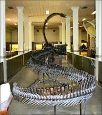
 In 1903 the Museum of Geology along with the Department of Geology and Mineralogy, moves to the Main Building.
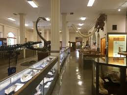
 A number of large endowments over the years, have helped contribute to the
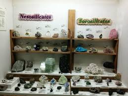
 Dallol is a cinder cone volcano in the Danakil Depression. It is located in the north and eastern region of the Erta Ale Mountains in
 These chemical discharges result in black, gray, green, pink, red, turquoise, yellow and multi-color white, deposits, which provide for a
 Travelers
 The island of Vieques, in Puerto Rico, features the brightest bioluminescent bay in the world. The magical quality of this
  Mosquito Bay also known as the Bio Bay, locally Puerto Mosquito, is considered the best representation of a bioluminescent bay in the
  In Mosquito Bay, there is supposedly more than 750,000 dinoflagellate per gallon of water. This is the highest concentration
  The Chilean Museum of Pre-Colombian Art in Santiago, is among one of the
 The Foundation would provide the art and in exchange the city of Santiago, would not only provide the building, but the operating and management expenses.
 Area Centrales, offers masks from the Moche, and some wonderful textile samples. A painted cloth from the Chavin, is dated from near 3,000 years ago.
 The Museum of Gold in
 Exhibitions begin on the second floor. The main display room is known as the People And Gold In Pre-Hispanic Colombia. There visitors will see an
 The W.A. Clark Mansion also known as the Copper King Mansion is
 One of the most surreal places in the world is the Pamukkale Hot Springs and the ruins of the

 In the early 600’s Hierapolis would fall to invading Persian armies and would be struck by another devastating
 In the southeast regions of France, there remains an architectural treasure from the ancient world. It is the Roman Aqueduct of Pont Du Gard. The structure built possibly around 19 BCE, is a testament to the builders, who created an engineering marvel, that survives to this day. The construction made out of limestone is both beautiful and practical in function, carrying both water and people across the Gardon River.

 The Pont du Gard aqueduct may well have been used as late as the 6
 It is thought the Nimes aqueduct system would have taken about 15 years to build and would of employed anywhere from 800 to 1000 people to complete.
 The Pont du Gard was constructed mostly without the use of mortar or clamps. It contains an estimated 50,400 tons of limestone, with a total volume of 740,000 cubic feet. Some of the individual blocks weigh up to 6 tons.
 The following century would bring increasing attention by the French government and those interested in traveling to see unique historical sites.


 RSS Feed
